This is a longer post. If you received this via email, it may get cut off. Read the full version on our website.
2025 is history. I have tried to capture highlights here but so much has happened that I may have missed a thing or two. Not much good transportation news out of Washington but some good news locally. Some of the highlights are chronicled below.
One of many great Madison Bike Week 2025 events: An infrastructure tour with city traffic engineer Jerry Schippa
We value your support of Madison Bikes. As a board member, I’ve been so impressed with what Madison Bikes accomplishes without paid staff. That’s partially due to hard work by board members, but the willing, hardworking volunteers we have are vital to our success. Our success relies on people like you – whether you volunteer at an event, advocate for safer bike facilities with your alder, read and share our weekly updates, attend our events, or simply ride your bike for transportation. It truly takes a village, and every contribution reinforces our message.
Bike Week
The Pride Ride, with over 200 riders kicked off Bike Week (Photo: Beth Skogen Photography)
What an inspiring event! Another huge turnout with 89 events and over 300 attendees at our end of week party. Bratcakes on the path, Party with a Pig, Wonders of Physics, Cheddar Waffles and Lattes, an infrastructure tour, and so many more fun and informative events. In case you’re interested, Bike Week 2026 is May 31 through June 7. Start cooking up your event now!
Infrastructure highlights
More good infrastructure was built this year, and more is on the way. Input from bicyclists was critical for some projects (see below). It’s really nice to see pieces of the network filling in.
The new cycletrack on Wilson Street, in front of Monona Terrace. People walking and biking have their separate spaces, demarcated with tactile paving strips.
In August, we joined the mayor and city staff to celebrate the completion of the Wilson St two-way cycletrack. The seven-year project provides all ages, all abilities access to downtown Madison connecting key downtown corridors with a less strenuous grade to the square. This project would have looked much different without public input. Thanks to all who provided comments. Here’s a video showing the Wilson St. Cycletrack just before opening.
The crossing of the Southwest Path at West Wash, still with two lanes in each direction at that point (Photo: Harald Kliems/Cyclists of MSN)
One high profile project focused on a critical crossing at West Wash and the Southwest Path. This intersection saw a spike of people on bikes being injured. After much deliberation and critical input from cyclists, a solution was reached. Most important was narrowing W Wash to one lane at the crossing with the help of temporary construction barrels. In the medium term, this configuration will be made permanent, and instead of a flashing beacon (RRFB) a full traffic signal will be installed. A detection system will trigger the traffic signal automatically when path users approach the intersection. Other options were not possible because of restrictions imposed by the railroad. One concern is whether path users will consistently wait for the signal before crossing.
After 8 years of a dead-end path on Zor Shrine Place, Phase 2a of the West Towne Path is finally open to High Point Rd. For cyclists, this removes an increasingly busy crossing at High Point Rd and a congested stretch along D’Onofrio Dr, and provides easy access to the excellent overpass of the Beltline on High Point Rd.
A contraflow lane on W Gilman was finished linking University Ave and the campus to the State Street area. This should reduce bicycle-pedestrian conflicts on the narrow sidewalk.
The Badger-Rusk Path (Illustration: Harald Kliems. Aerial imagery: Dane County)
The Badger-Rusk shared use path was completed this fall.In this project, bike lanes were replaced by a 0.4-mile-long, grade separated path along W Badger Rd and N Rusk Ave. A nice link in the bike route that connects existing paths on W. Badger Rd and N. Rusk Ave as well as a pedestrian overpass over the Beltline.
The first section of the North Shore Drive Path was completed this summer and provides a link from the SW path to Bedford St. Next year, when bicycle traffic is detoured for JND construction, this path will become more significant. When John Nolen Drive is completed the link will extend all the way to Bassett and Broom, helping to solidify the network on the isthmus.
The Autumn Ridge Path Overpass was completed in December of last year but the ribbon was cut in 2025. The project connected Sycamore Park and Milwaukee Ave. via a bridge over Highway 30 resulting in a safer route. We had a great time celebrating the ribbon cutting with the mayor!
Mayor Satya Rhode Conway, City Engineer Jim Wolfe, and project engineer Aaron Canton cutting the ribbon on the Autum Ridge Path (Screenshot: City of Madison)
Some infrastructure we’re watching in 2026
Progress on JND reconstruction with separation of bike and pedestrian paths
The repaving of Midvale Avenue has been delayed. After a contentious debate about turning on-street parking into buffered bike lanes, city staff have proposed to patch up the existing street without any changes and make more fundamental changes as part of a full reconstruction. Timing to be determined.
We had so many good meeting ideas for 2025 that we had to push some off to 2026. Again, we had a variety of events. This resulted in an awesome spread of topics and events. Of course there was International Winter Bike Day in February. We provided coffee and donuts for over 50 participants on a cool winter morning. The wood stoves this year may have enticed some to stay a little longer.
International Winter Bike Day on a crisp morning
This year’s April bike wash was as popular as ever. We washed lots of bikes, and did some on the spot checks, and had lots of good discussions with new and not so new bicyclists.
April Bike Wash
Madison Bikes partnered with the Wisconsin Bike Fed and Machinery Row to host a presentation by Madison Bikes board member Alicia Bosscher and her father Dirk Debbink. It was a first-hand account of pushing for change following the death of Sarah Debbink Langenkamp to traffic violence, the inception of the “Sarah’s Bill”, and its bipartisan progress through Congress. It was fascinating to hear how this exceptional work building bipartisan consensus is possible today.
Bike Fed, Machinery Row Cycles, and Madison Bikes co-organized a series of three book club discussions of Killed by a Traffic Engineer. The sessions were moderated by alder Bill Tishler.
The Bike Touring/Bike Packing Social at the Goodman Center was also popular. A great venue for sharing touring stories.
We have lots of ideas for 2026 but we’re always open to new ones. If you have an event that you’d like to organize with us, don’t hesitate to reach out!
Ride the Drive – wait til next year
All of the prep for our site on John Nolen drive was done. The smoothie bikes were ready to go and staff had been lined up. Unfortunately, a perfectly timed flood washed out this year’s event. Wait until next year. We couldn’t be that unlucky twice, right?
Administrative changes in city transportation
Renee Callaway, Bike/Ped Administrator and later Assistant Director in Traffic Engineering, retired after a distinguished career in bicycle planning, outreach, and engineering. We’ve been lucky to have her working to improve bicycling all these years. Fortunately, we have an able replacement, Kevin Lueucke, formerly of Toole Design. Kevin will manage the Traffic Engineering’s Pedestrian Bicycle Section, with staff responsible for pedestrian and bicycle concerns, projects and outreach, playing a role in related initiatives like Vision Zero, school traffic safety and Complete Green Streets.
Renee Callaway retires
Tom Lynch retired after seven years as Director of Transportation. He was a solid supporter of active transportation and improving transportation safety through projects such as Vision Zero and Complete Green Streets. We are grateful for his service. He is succeeded by Christof Spieler, a professional engineer with extensive experience in urban planning. He has written, “Trains, Buses, People: An Opinionated Atlas of US and Canadian Transit.” A new book on the geometry of urban transportation will be published soon. Spieler has spoken and written extensively on transportation, urban planning, and sustainability coming to us from Houston. We look forward to perspectives he has developed working for several large cities in the U.S. He’ll be at our community meeting on January 22 so we can get to know him.
Spring elections
For the spring elections, Madison Bikes partnered with Madison is for People, Madison Area Community Land Trust, Affordable Housing Action Alliance and Strong Towns Madison on a questionnaire for Madison Common Council candidates covering transportation, housing and sustainability. We hope this helped you to get to know the candidates and make appropriate choices. And remember: Half of all council seats will be up for election again this spring!
Area Plans
Area plans are critical in transportation infrastructure. These plans only get updated every 10 years so it’s important to get involved when a review is underway. The West and Northeast plans have been adopted, and the Southeast and Southwest plans are now center stage. The city learned from prior plans and went all out to get input from the citizenry for the Southeast and Southwest plans. Input was not just on line but meeting people where they are in a variety of settings and formats.
Both plans are in Phase 3, review of the draft plan, with Phase 4, adoption and implementation expected in May 2026. The Southwest plan timing isn’t perfect because decisions made in the DOT’s Beltline PEL Study could have a major impact on bicycle transportation in this plan. Some good things in the plan include an All Ages & Abilities facility along Seminole Hwy from the Beltline to the Cannonball path, extending the Hammersley Path west to Elver Park, and flexibility built into the plan for Beltline crossings if the DOT approves these.
The Southeast plan is also in Phase 3. This plan is also complicated by the DOT’s Highway 51 project which impacts land use recommendations. There is uncertainty because of varying opinions on the design (high speed vs lower speed with more intersections) of Highway 51. There will likely be some improved crossings, and wayfinding, but the biggest bike/ped issues will be related to crossing or traveling parallel to Highway 51.
Madison Bikes granted $2,270 in small grants to seven organizations during 2025. These grants include materials to paint a street mural outside of O’Keefe Middle School and a grant to RideABLE UW-Madison Mechanical Engineering Senior Design Team for bike parts needed to transform a semester of design work into a fully functional adaptive trike. Do you have a project idea? Take a look at our Small Grants page and consider applying! https://www.madisonbikes.org/small-grants/
Bicycle Film Festival
A near capacity crowd for this year’s BFF
Our first Film Festival, Madison’s first ever, went well in 2024 with over 250 attendees. This year an even larger crowd attended on another beautiful evening and loved it. It will be back due to popular demand in 2026!
Winter Bike Fashion Show
The Winter Bike Fashion Show returned this year to rave reviews. Who knew that so many people (well over 100) were interested in winter biking. I guess we did but it was nice to see so many show up. What a great way to end the year! We also interviewed some attendees about winter biking — find the video clips on our YouTube channel!
Fashion show model struts her stuff
I hope you enjoyed this recap. Have a happy 2026 everyone!
This is a guest post by Wisconsin Bike Fed staffer Ben Varick. It was originally published on the Bike Fed’s blog and is republished with permission. You can sign up for the Bike Fed newsletter or support their work with a donation on their website: https://wisconsinbikefed.org/
The Southwest Path overpass over the Beltline (Photo: Harald Kliems)
The Wisconsin Department of Transportation’s plan to widen the Beltline will make air and noise pollution worse, increase carbon emissions, and commit our region to costly maintenance for decades. Time and time again, highway expansions have shown to increase traffic congestion and encourage sprawl. There are better options for our transportation system.
The Wisconsin Department of Transportation (WisDOT) is planning a major project on the Beltline to the West and South of Madison. They just released the results of their planning study and their proposal is to add another lane and rebuild the existing interchanges to increase car traffic. This is shortsighted and misguided. We need your help telling WisDOT that this plan is not what we want.
By 2050, the City of Madison’s population is projected to grow 42% and the rest of the Dane County is likely to grow similarly. This is a significant increase and will require thoughtful infrastructure to welcome our new neighbors.
WisDOT plans to address the growing population by increasing the number of lanes on the Beltline (and I-39/90/94). Now on the surface, this might seem like a good idea: if there are more people, and those people are driving, you need more space for those cars. And this has been the philosophy of many transportation agencies since the 1950s, with very poor results.
Induced Demand
Increasing the lanes on a highway does reduce traffic in the short-term (1-5 years). But then some people change their transportation habits to drive more, some people move farther from their jobs and drive more, some businesses that rely on driving (i.e. Amazon warehouses) move in. This causes the traffic on the stretch of road that was widened to return to an equilibrium that is as congested as it was before. This is called induced demand, this article from the New York times, this article from Wired or this video from Not Just Bikes are good explanations of the phenomenon. Verona Road was widened 4 years ago and already “traffic volumes have exceeded projections along the Verona Road corridor”.
We spend hundreds of millions of dollars on widening highways, commit ourselves to billions more in maintenance costs, and the congestion on the road is the same. And all of those new car trips start or end on surface streets, making those streets more congested. This will make our region more car-dependent, putting a higher financial burden on families and reducing the autonomy and freedom of movement for the ~40% of residents in the Madison area who are not drivers.
WisDOT is not incorporating induced demand in their models of this project’s impacts. In part, this is because modeling induced demand is quite difficult, which is true. To ignore induced demand and then make claims about reducing congestion is a glaring oversight. Chris McCahill at UW’s State Smart Transportation Initiative recently wrote a great article about how transportation agencies can include induced demand in their decisions even when precise modeling is difficult. He summarizes induced demand nicely: “Build for cars, and you’ll get more driving; build for transit or biking, and you’ll get more of those too.”
One of the proposed “improvements” on the Beltline is to increase car throughput at various interchanges. This will make traffic flowing onto the local roads faster than it already is. One of those interchanges is at Gammon Road, where we’ve written about the dangers for students walking or biking to Memorial High School and Gillespie Middle School. Gammon Road is on the City of Madison’s High Injury Network and in MMSD’s Unusually Hazardous Area. The planned interchange expansion at Gammon will increase the speed and volume of car traffic, increasing the risk for students and families at those schools.
What’s the Alternative?
The mindset among state transportation agencies is finally starting to change. Among others, the Colorado, Minnesota, and Michigan Departments of Transportation have started to cancel urban highway expansion projects. In Rochester, NY, the city removed a highway that went to through the city and replaced it with a boulevard, a bike/pedestrian path, apartments, and shops. The New York Times wrote a great article about highway removal projects and their impacts a few months ago.
Traffic currently gets congested at rush hour, and as more people move to Dane County, there will be more demand on our transportation system. But building more lanes on the highways around Madison will make the congestion worse. In order to reduce traffic, we need to start thinking about how can we move the most people as possible, instead of how can we move the most cars.
Congestion is a geometry problem: bikes, buses, and walking take up far less space than single occupancy vehicles. Here is the amount of space taken up by 60 people using different forms of transportation.
Imagine if the extraordinary sums of money proposed for these highway expansions were instead spent on building bike paths connecting more areas to a safe bike network? Or if we used the money to build more transit lines serving other parts of the Madison area? Or if we finally build the train line that connects Madison to Milwaukee, Chicago, and Minneapolis? Or if we allowed grocery stores to be built in residential neighborhoods so people could walk to them? Or if streets were made safer so that kids could bike to school? These ideas would all reduce traffic for everyone and will make our cities nicer to live in.
We don’t need people to stop driving all together (nor is that possible), we just need to give people alternatives to driving that are safe, comfortable and efficient. Every trip that is walked, biked, or bused is one less car trip on the road, and less car traffic.
“There is no solution to car traffic, except viable alternatives to driving.”
– Not Just Bikes
How you can help
The City of Madison and surrounding municipalities are doing a lot of these ideas, but WisDOT’s plans to expand the Beltline will hinder their efforts and make our cities and towns less livable.
While these highway plans also include some bike, pedestrian and transit improvements, they are vastly overshadowed by the negative impact that the increased traffic will bring. WisDOT has the potential to support great improvements to our transportation system, highway expansions are not those improvements. We support maintaining the existing roadway – Strategy Package 1 (SP1) – but with the proposed bike and pedestrian connections. This combination is not currently an option that WisDOT is willing to consider, help us change that!
We need to tell WisDOT and our local elected officials that these highway expansions are a mistake that we need to stop digging ourselves into a deeper hole.
The Midvale resurfacing survey was poorly constructed; its options were not even remotely comparable. City Engineering needs to do better when crafting future surveys.
Over a quarter of the written responses offered nothing of substance about the survey questions; many were simply grievances about City projects or the City’s support for bicycling. If these are excluded from the results, options 1 and 3 end up with similar levels of support.
Parking removals along Midvale are an inconvenience to residents, but they are not a hardship. All sixty homes have ample off-street parking and most have room to add more. On-street parking is seldom used today due to the high risk of cars being hit.
Midvale bike lanes have been in City plans for 50 years and there is proven need for them. Painted lanes are not ideal, but they are an economical improvement until the road is fully reconstructed in 10-15 years.
Resurfacing Background
Midvale Blvd north of Mineral Point Rd is going to be resurfaced in 2026. Compared to reconstruction, resurfacing is relatively low cost since it involves only a new layer of asphalt and painting new lane lines. There may be light curb work done, but the overall road geometry is left alone. By resurfacing in 2026, the City hopes to delay a full reconstruction of Midvale for 10-15 years. A full reconstruction will cost much more and includes stormwater, utilities, curb, medians, sidewalks, bike facilities, etc.
Plans to add bike lanes to Midvale Blvd go back to 1975, but north of Mineral Point Rd the curb-to-curb width does not have space for bike lanes and on-street parking and two vehicle lanes in each direction (the road is wider south of Mineral Point Rd and the City long ago painted a shared bike + parking lane there).
In 2023, the City first explored converting Midvale Blvd parking lanes to bike lanes as a Safe Streets For All (SS4A) project. In late 2024, a combined resurfacing + bike lane project was introduced. Information from those past meetings can be found at the Midvale Blvd Resurfacing & Safety Improvement Project page. In summer 2025, the City sent out a public survey asking for feedback on three options for bike facilities:
option 1 paint bike lanes on Midvale Blvd and remove street parking from most of the road.
option 2 move bicyclists to a quiet side street and have them cross multi-lane University Ave and Midvale at un-signalized intersections.
option 3 make no changes to Midvale, but do make minor improvements to Mineral Point Rd crossings at Segoe Rd and Owen Dr.
This survey had serious flaws. Its three “options” were not remotely equivalent. Option 1 was the rare chance to improve the connectedness of the Hilldale area by executing on 50-year old City plans and complying with long-standing City policies, all while having zero effect traffic and drivers. Options 2 & 3, on the other hand, were minor window-dressing projects on well-established bike routes. In fact, option 3’s improvements were so minor that City engineers have admitted they’re going to do them regardless of what happens with Midvale resurfacing.
Additionally, the options were loaded with technical jargon and diagrams rather than visual renderings. This may account for the large number of respondents (at least 11%) who misunderstood what was being proposed. The survey’s creator also seemed to favor option 3, as evidenced by lopsided “pros and cons” listed for each option.
Finally, surveys like this should not be designed like votes. That skews the way people respond to the survey, and it gives the wrong impression to policy-makers looking at the results. E.g., I support the improvements of option 3, but could not say so when taking the survey because I knew that would throw “votes” towards that option.
The survey generated record-setting amounts of public input – around 2500 responses and 1400 written comments. The results were presented at the Sept 20 Transportation Commission (T.C.) meeting. Below is a summary:
Option 3 was the clear winner in the survey, yet the T.C. voted for option 1 because it was the only one that addressed the City’s long-established area plans and transportation policies. I.e., it was the only option that improved bicycling in the area.
City Alders all spoke and voted strongly against option 1 because the loss of street parking would affect about sixty households. The meeting recording is worth watching (Alders and T.C. discussion happens around the two-hour mark). The Alders will now try to overturn the T.C. recommendation at Common Council. In describing her fight to overturn the T.C. vote, Ald Regina Vidaver cites “the overwhelming opposition of the public” to option 1.
Is that true? Was there really overwhelming opposition to option 1, bike lanes? To test this, I and a few volunteers cataloged all 723 written responses from people who listed option 3 as their main choice. Here is the raw spreadsheet for anyone to check the work or do their own analysis. Option 3 was analyzed because it was the option chosen by nearly everyone! It was chosen by bike-lovers and bike-haters. It was chosen by those wanting to preserve street parking and by those concerned for pedestrian safety. It was chosen by people with detailed and well-considered ideas about traffic engineering, as well as those venting about no-turn-on-red signs. So why was option 3 chosen by so many different factions?
Below is a summary of our findings with select quotes.
Analysis of responses to option 3
Note: the groupings below do not add up to 100% because responses could be counted in more than one grouping.
Only 11% of responses mentioned the actual option 3 improvements
I am really excited about the possibility of these improvements
Option 3 provides an even safer route for an existing route many already take, including middle school students, due to the biking lanes already present on Segoe
Owen Drive is a main pedestrian walking route for children living in the Sunset Village neighborhood as they walk to School (at Queen of Peace or Midvale Elementary). Improving that intersection along with the proposed pedestrian safety improvements to Midvale would make a huge positive impact to the walkability/bikability for residents and commuters alike.
This shows 11% of respondents understood the proposed crossing improvements along Mineral Point Rd at Owen and Segoe. Those improvements are so clearly worthwhile that City Engineers at the T.C. acknowledged they’d go ahead regardless of what happens with Midvale resurfacing.
But the fact that 89% of responses made no mention of the improvements suggests that option 3 was mostly a protest option. I.e., it represented the least change, the least cost, the closest to the status quo. For many who chose option 3, its improvements were beside the point.
28% were openly hostile to any bike facilities and/or past City projects.
And half of them also made negative mention of Segoe’s protected lanes, Whitney Way’s parking removal, BRT lane changes, no-right-turn-on-red signs, and other traffic grievances:
Listen, you pencil-necked bureaucrats, you’re at it again, aren’t you?
For God’s sake leave Midvale alone and leave something un-f’d up.
Stop harming people who need to drive vehicles in favor of virtue signaling.
The Segoe redo is a disaster for driving and there are virtually no bikes that use it.
11% mistakenly believed option 1 would remove vehicle lanes or erect concrete protected buffers.
I oppose any options that reduce traffic lanes on Midvale
The Option 1 plan seems to mimic what was created on Segoe Rd from University Ave to Regent Street
if you add bike lanes that block cars from being able to pull over to let emergency vehicles though, YOU will have blood on your hands!
This misinformation was common on social media, and probably resulted from the survey’s lack of visual renderings.
To be clear, option 1 adds a simple painted bike lane and does not remove any traffic lanes. They’re not that different from the lanes on University Avenue in that same area.
22% mentioned street parking.
This is the main opposition point: the removal of street parking needed to add bike lanes. This group is discussed in more detail later on. For a third of these responses, parking was their one and only one concern.
Losing parking on Midvale is not fair to homeowners.
People living on Midvale need to be able to have on street parking, don’t take it away as you did on Whitney Way.
The residents who pay property taxes to the city should take priority over construction projects that will benefit others that do not live there and also decrease those residents’ home values
16% of respondents self-identified as bicyclists.
1% preferred the status quo, 4% would support a bike lane if it were protected (like N. Segoe), and the other 11% felt that since they don’t ride on Midvale, no one else needs to either.
I personally don’t like biking busy streets so that’s why I’m against option
I am a biker and I will always choose a route that is less hazardous than going on Midvale. Even if you make improvements I wouldn’t use them.
as a biker, I never felt Midvale Blvd was a safe option for bike riding.
6% mentioned cost
It is fiscally irresponsible to undertake another expensive project so close to the recently completed Segoe Rd. project.
The city of Madison would be extremely short sighted to undertake such a large project at the taxpayer’s expense while benefitting only a handful of cyclists.
How can this be in a supposed stretched budget? This mayor overspends my tax money
The survey did not discuss costs, other than mentioning that cost savings was a benefit of option 3. The City budget shows $2.75M to resurface Midvale Blvd and implement all pedestrian crossing upgrades and signal improvements. The cost of the three bike options are not broken out, but an educated guess is $150k for option 1, or $50k for options 2 or 3. I.e., all are less than 5% of the project budget.
To put $2.75M into perspective, consider that Rimrock resurfacing is $1.1M for a similar length and width, while Virginia Terrace resurfacing is $2.6M for a road half as long and half as wide. These projects have a lot of cost variability.
25% were “nanny” responses.
These responses believe they’re looking out for the interests of bicyclists by discouraging them from riding on Midvale. These respondents ignored the many reasons why bicyclists might want or need to take Midvale.
Directing bike traffic to nearby, less-traveled streets looks like a better option that will be safer for both bicyclists and motorists.
Keep us safe and keep us off Midvale.
Best move the bikes to neighborhood streets parallel to Midvale.
30% of responses seem to be pure protest votes against the City, against bicycling, or in favor of car-only roads.
This group of responses does not mention street parking, nor do they say anything favorable about safety improvements, alternate bike routes, or crossing improvements. They show little understanding of the resurfacing project nor the options presented by the City engineers. They also show little concern for the problems of the current road (e.g., speed) and for neighbors who live, park, walk, and bike in the area.
This is why people hate you. You and your clipboards, your “community input” meetings where the same three NIMBYs show up to whine.
too.much is spent on idiotic accommodations for bikes.
Construction on Midvale for pedestrians is a waste of money and time
These are valid voices, of course. But are they constructive? Do they deserve the same weight as the other thoughtful comments, especially when many interpret the survey as a democratic vote?
If those 30% of pure protest responses are excluded, the “overwhelming opposition of the public” claim withers and options 1 & 3 are left with similar public support:
Bicyclists use Midvale Blvd in high numbers today, even though it has no official bike facility.
For bicyclists crossing University Avenue, Midvale Blvd is by far the most popular place to cross in the two miles between Whitney Way and Highland Ave.
Of bicyclists traveling north or south of Regent St, slightly more choose Midvale Blvd than the alternate routes on Segoe or Owen.
Segoe and Owen are both excellent bike routes, but they do not serve all riders and all destinations:
Midvale is where the shops, groceries, schools, hardware stores, banks, medical offices, restaurants and library all are. Midvale is part of a 15-minute city.
Midvale is the shortest and most intuitive connection between the Southwest Path, the University Ave / Shorewood Path, and the Regent / Kendall bike boulevard.
Segoe & Owen alternate routes can also be longer, slower, steeper, and require crossing busy Mineral Point Rd, Midvale Blvd, and/or University Avenue without a stoplight. They are also unintuitive to those new to the area, navigating by GPS, or only familiar with major roads.
Below is the biking data from Strava, an activity tracker used by many athletes and commuters. This data is very useful for understanding how popular different routes are, but it is not good for counting the actual number of bicyclists. Click the image for a better view.
The case for on-street parking
Nearly every major road from University Ave to Monroe St has had parking removed or restricted at some point in the past. Here is how Wisconsin State Journal reflected on Regent St rush hour parking removal back in 1960:
This has hurt some merchants and regrettably so, but the council has acted for what it feels to be the greater good.

A policy, to be valid, must be applied impartially. That means Regent St., as well as the many other streets in the city where parking has been restricted.

If the policy isn't applied impartially, then it had better be discarded, and we'd better remove rush hour restrictions from other streets as well...
Every City must weigh the needs of thousands of daily motorists, bicyclists, pedestrians, and bus-riders against the needs of the adjacent landowners. In business districts that lack off-street parking, the economic aspects often win out and influence road designs, as happened on S. Park Street with BRT. In residential districts, especially those with ample off-street parking, the homeowner resistance usually loses out to City policy and plans.
Madison policy has favored transportation over parking since at least the 1950’s, and that policy is now enshrined in the Complete Green Streets modal hierarchy where street parking is dead last compared to all other needs:
source: Complete Green Streets Modal Hierarchy https://www.cityofmadison.com/transportation/initiatives/complete-green-streets
In the Midvale survey, 161 responses (22%) were in favor of preserving parking, with most comments mentioning the homeowners of the sixty properties south of Regent St:
We have elderly family with mobility issues that will no longer have access to our home.
Removing the Midvale parking will create an inconvenient and dangerous situation for guests and contractors visiting Midvale residences.
Option 1 is unfair to the numerous homeowners on Midvale. Being completely unable to park on the street outside their homes would be a hardship.
The City did numerous counts over two years showing that those homeowners rarely use street parking. How does that fact square with the homeowner pleas to preserve parking?
An examination of the sixty houses shows that nearly all have garages and at least two off-street parking spaces. Most have yard space to add more parking and some have already done that.
All affected homes are less than a block (600′) from off-street parking on quiet side streets.
During public meetings in 2023 and in early 2025, multiple residents explained the low street parking rates were due to the fact that cars get hit when they’re parked on the street.
Crash data from Community Maps confirms that. It shows 17 crashes with parked cars along Midvale in the past 15 years. For comparison, the similarly long stretches of Regent & Bluff had twelve crashes, Mineral Point Rd had four, Owen had five, and Segoe had zero. Midvale appears to have the highest rate of parked car crashes west of the isthmus.
(That brings up the topic of Midvale Blvd speed and safety that was mentioned by at least 13% of respondents. They were near unanimous that the street is becoming unbearable to live near. All wanted the City to do more to control speeds and reckless driving.)
The homeowner protests are real and sincere, but also a bit hollow given how little they use street parking, how much off-street parking they have, and how hazardous it is to park on the road. I wonder how they feel about nearby Mineral Point Rd where there is practically zero usage of street parking. I also wonder about fairness and impartiality: don’t people who live in no-parking areas of Regent St or Commonwealth or Glenway also have contractors, guests, or elderly family with mobility issues? And most importantly, I wonder if this is really an issue of hardship, or is it one of convenience?
I also wonder if the the public would be so defensive of street parking if this project was adding a motor vehicle lane rather than a bike lane… What would the survey results look like then?
The case for compromise
At the T.C., the project was presented with no room for compromise. That’s a shame because there are options.
For example, empirical and anecdotal data suggest that Midvale bike lanes are needed most between Regent St and University Avenue. That’s the business area around Hilldale Mall with many businesses and apartment buildings. One compromise could be to only add bike lanes on that stretch.
Or consider that Midvale Blvd south of Regent St is a big hill. Since northbound downhill bikers travel faster and are more in need of lane space, another compromise might have a bike lane only in the northbound direction.
Several survey responses suggested widening the Midvale sidewalks into paths, like the path along Hammersley Rd. That’s far too costly for the resurfacing project and would also require tree removals and/or yard encroachment. But if there’s enough buy-in from the homeowners, maybe the Alders could drive this idea forward.
I’m personally not a fan of any of the street compromises, but politics involves concessions. At this point, it’s for the Alders to figure out and they should be thinking about all available options.
I do think City policy statements and minor ordinance changes could also address resistance to parking removal. For example, several people mention the need for short use of the street for deliveries, shuffling cars in the driveway, picking up and dropping off, etc. The City should make it clear that temporary “stopping” and “standing” are allowed along the curb provided the vehicles engage their hazard lights. This is what exactly what delivery drivers do today throughout the city, and it works fine. Some people also mention the need for parking for parties or garage sales; the City could adapt street occupancy permits to allow for such events during non-peak hours.
Last word: Shared bike + parking lanes
Any compromise will likely leave gaps where bike lanes disappear and where bikers will need to ride in unofficial 9′ shared bike + parking lanes that are even narrower than the 10′ shared lanes Midvale has today south of Mineral Point Rd. NACTO frowns on shared bike + parking lanes, but Wisconsin seems to like them. The 2004 Bicycle Facility Design Handbook (pg 2-14) specifies 12′ minimum width while the 2003 Bicycle Planning Guidance (pg 39) specifies 14′.
A design point is the right-side painted line. Where it exists, drivers naturally expect bikers to stay to the right of it. But what happens when that’s not possible? The bikers are the ones who finds themselves in sketchy and uncomfortable situations. At those times, it’d almost be better to NOT have that right-side painted line.
This point brings to mind survey response no. 491:
I observe that the few cyclists who do chose to use Midvale Boulevard seem to be intentionally making a point. They either occupy a full traffic lane, or swerve out into traffic around parked cars. They seem to be engaged in dangerous performance art or protest.
I guess one person’s survival skill for navigating bad infrastructure is another person’s performance art!
Editor’s note: This is a blog post by Katie Nash, one of our board members and board secretary. Katie rides to work year-round (when it’s above 20 degrees and not raining!) on either a gravel bike or fat tire bike, and prioritizes travel based on being able to use her bike. She joined the board in January 2024 and is excited to be part of a bike community that can advocate for and influence change within Madison. Katie works for UW-Madison and is part of the UW-Madison Libraries. When she’s not riding her bike, she enjoys kayaking, hiking, and exploring the Driftless Area with her partner, Timothy; and hanging out with their three cats. Opinions are her own.
I have vivid memories of my kindergarten teacher, Ms. Swan. She gave us the warmest and most welcoming hugs the first day we stepped tentatively into her classroom and she had a giant stoplight in a corner of her classroom. She used it to teach us that red means stop, yellow means slow, and green means go. I’ve lived in three different states and Madison, Wisconsin is the most bicycle-friendly place – I love it!
But I’m appalled by the number of automobile drivers who run red lights in this city, at almost every intersection. The lack of enforcement makes this behavior tolerated, and extremely unsafe for pedestrians. I don’t have hard stats to show how many drivers run red lights, but as both a driver and a dedicated bike commuter and distance cyclist, I do have firsthand experience.
When I’m driving, I notice people running stop signs or red lights; when I’m bicycling, I’m keenly attentive to such violations. The number of cars running red lights has increased each year since I moved to Madison in 2018. I’m seriously concerned – the disregard for red lights and following the law is dangerous for pedestrians, bicyclists, and drivers. I began to feel frustrated, agitated, unsafe, and confused about this egregious behavior so I started recording drivers running red lights in real time using a camera on my helmet.
This is normal behavior at almost every intersection across the city, no matter the neighborhood.
I also did research and found crash maps in the yearly City of Madison Crash Facts Report on their Vision Zero Safety Data page. The current Vision Zero Madison action plan has a goal to advocate for automated traffic enforcement (see page 33, goal 7.1). It’s unreasonable to expect the City’s traffic and transportation engineering departments to design streets that stop all speeding and signal violations or to expect traffic enforcement to fall solely on the shoulders of the Madison Police Department. We need multiple ways to help curtail the rampant number of cars running red lights.
Current state law makes it illegal to use any sort of automated enforcement—such as cameras commonly used in many other cities and states—to enforce speed and traffic signal violations. Milwaukee is pushing the Wisconsin State Legislature to allow the city to use automated enforcement cameras to catch speeders and red light runners – read online to learn more. In March 2023, Assembly Bill 85 (AB85) was introduced to the Wisconsin Legislature to modify the law, providing a glimmer of hope that technology can help reduce speed and traffic signal violations. Sadly, it failed to pass in April of 2024. We need to advocate and push for safe streets for all!
What can you do?
Write local politicians expressing your concern about increasing traffic signal violations (especially automobiles running red lights) and your support for increased enforcement.
Ask politicians to re-introduce a bill to implement the use of automated speed enforcement systems and traffic control photographic systems in cities such as Milwaukee and Madison that will provide a penalty to those who violate the law.
Write local leaders and government agencies who focus on transportation, traffic safety, and pedestrian and cycling issues – ask them what is being done about traffic signal violations. Express how unsafe this behavior is for pedestrians and bicyclists and ask how you can get involved to help make change.
Be a respectful pedestrian and bicyclist – lead by example and follow traffic signals. Spread the word: tell your friends and family about this growing problem. Let’s make sure this city remains one of the top bicycle friendly places in the nation!
Only a few more days are left in 2024. What were some of this year’s high and low lights for biking in Madison and for Madison Bikes? Here’s my personal perspective. As always, I’m sure I’m forgetting some things! And the post is still going to be long enough that Mailchimp may cut it off.
Before we get into it, I want to thank all of you, our readers and supporters. We’re a small organization, with no paid staff. And so we rely on all of you to make biking better in Madison. You are the ones volunteering. Advocating for bikes with your alders, neighbors, or on (gasp!) NextDoor or Facebook. Writing posts for the newsletter. Reading and forwarding the newsletter. Running for our board or elected office. For showing up at our events. And for donating. We really appreciate it.
Madison Bike Week
“Ride with the Pack” got rained out, unfortunately
Every Madison Bike Week is different. All of them are awesome, and 2024 was no exception. We had some worse-than usual luck with the weather, with several events early in the week getting rained out. But overall we once again we had a wonderful mix of familiar and new events. Biking with your dog. A vintage bike ride. A blessing of the bicycles. The return of Bratcakes. An e-bike expo. Infrastructure tours of the south side, east side, and Middleton. And so on. 89 events total, all organized by individuals, government agencies, community groups, or local businesses! Save the date for 2025: Madison (and Wisconsin) Bike Week will take place from June 1-8.
Infrastructure highlights
I continue to be amazed how much new infrastructure has been completed in the last few years. The city has been exceptionally successful in getting state and federal dollars. And we now see the results of this funding materialize on our streets and paths.
On the east side, the Autumn Ridge Path and overpass form a brand new low-stress link across Highway 30, connecting Sycamore Park and Milwaukee Ave. No longer do you have to contend with drivers through the Thompson Road roundabouts or the cut-through traffic on Swanton Road.
Last year we celebrated the completion of the Broom and West Wilson projects. And in 2025, work started to complete the protected cycle track along East Wilson, from Monona Terrace to the “hairball intersection” of John Nolen, Williamson, and Blair. The project didn’t quite finish in 2024, but some stretches are done already.
On the west side, phase 2 of the multi-use path along Hammersley was completed. Now you can go all the way from the crossing with the SW Path to Brookwood on a separated path.
Mineral Point Road Path
The biggest infrastructure project of the year was the opening of Madison’s first bus rapid transit (BRT) route. There were some negative impacts on biking from that: On about two miles of East Wash, the combines parking/bike lanes disappear during rush hour. But there are also upsides: On the new BRT buses, you can roll your bike on board rather than dealing with a rack on the front of the bus. And as Mineral Point Road was redesigned for BRT buses running in the center lane, the city built a new multi-use path on the north side of the road. There was a lot of controversy about the path: Bikes were pitted against trees (even though the root cause was a decision to keep two car travel lanes on Mineral Point Road). And people had concerns about the safety of a two-way multi-use path along a corridor with many busy driveway crossings. The jury is still out: I have biked on the new path a few times (stay tuned for a video!), and I think overall its somewhat of an improvement over what was there before.
Segoe Road and Sheboygan Ave were both rebuilt this year. Segoe got a curb-protected bike lane from Regent to Sheboygan; and Sheboygan was upgraded from having no bike infrastructure at all to buffered bike lanes. We celebrated the completion of the project with district alder Bill Tishler.
Dane County Park also opened two amazing new paths this year: A new section of boardwalk connects Fish Camp County Park with Lake Kegonsa State Park. And along the shores of Lake Waubesa, a new trail connects Lake Farm and Goodland county parks.
This section is called infrastructure highlights, but there were also two major setbacks: After decades of planning and seeking funding, it looked like we were set for two trail extensions: The Cannonball Path was going to be extended from Fish Hatchery Road to the Wingra Creek Path. And the Cap City trail was finally going to extend past its current terminus on the east side and continue all the way to County Road AB/Buckeye Road. Plans were completed and approved. Funding secured. And then the Office of the Commissioner of the Railroad (OCR) shut it all down. The railroad company didn’t like the new crossings that are required for the two paths, and the OCR agreed with them. It remains to be seen how these projects can move forward in the next year.
Elections and new alliances
Pretty much every year is an election year, and 2024 was no exception. We continued our work of informing voters through candidate questionnaires and debates. This year, the Dane County executive and all county board supervisors were on the ballot.
Long-time executive and champion of many Dane County bike trails Joe Parisi resigned, and Melissa Agard and Dana Pellebon ran to become his successor. As part of the first ever Madison Housing Week, organized by the newly formed Madison Housing Coalition, the two candidates debated their approaches to housing, land use, and transportation.
For the county board election, Madison Bikes teamed up with the Affordable Housing Action Alliance (AHAA), Madison is for People, and Madison Tenant Power (MTP) for on an election questionnaire. We sent questions about making housing more affordable and how the county could better serve the 30-40% of Dane County residents who are non-drivers, and then published the responses on our website ahead of the election.
In 2025, our focus will be on the common council elections.
Area Plans
Speaking of land use and transportation: One key instrument in how our city plans transportation infrastructure, land use, parks, and utilities in the mid and long term is through area plans. The plans cover 13 areas of the city and, once in place, will be updated every 10 years. The first plans to be created and adopted were for the West and Northeast areas. While the Northeast plan was largely uncontroversial, the West area plan was anything but. And biking took a prominent role. One controversy was focused on the Sauk Creek Greenway and whether a bike trail through and across the area should be included in the plan.
Public meetings turned into shouting matches, NextDoor and certainly editorial sections were abuzz, and we did what we could to provide accurate information. In the end, the north-south path along the creek was not included in the plan. But an east-west connection was, as well as safe and protected bike infrastructure on roads parallel to Sauk Creek.
Now that the Northeast and West plans have been adopted by the Common Council, the process for the Southeast and Southwest plans has started. We’ll continue our coverage in the new year.
Community meetings
Winter Bike Social
One innovation for Madison Bikes in 2024 were monthly community meetings. We have hosted many events in the past, but this year we took a more deliberate and inclusive approach: In December of last year, our board members and anyone who was interested met up at the library over pizza and brainstormed ideas for events in 2024.
Touring the Arboretum
This resulted in an awesome spread of topics and events: Of course there was Winter Bike Day, where we handed out donuts and coffee on a freezing February morning. Renee Callaway from the city’s traffic engineering department gave a presentation about “Vision Zero and Active Transportation Planning.” BCycle Madison gave us a tour of their facility. We washed bikes with our friends from Freewheel to celebrate the end of winter. Bike lawyer and Madison Bikes supporter Clay Griessmeyer talked about what to do if you’re involved in a bike crash. An Ecological Restoration Specialist, Eric Grycan, led a bike ride through the Arboretum. Local author and silent sports disciple Timothy Bauer gave a talk about how to combine pedaling and paddling. And we wrapped things up with a Winter Bike Social.
BCycle Madison facility
Our planning meeting for 2025 took place two weeks and resulted in lots of great ideas. Stay tuned! If you have an event that you’d like to organize with us, don’t hesitate to reach out!
Remembering Joseph Solomon
On March 15, Joseph Solomon was biking home from work near East Towne Mall. A turning driver hit and killed Joseph. Fatalities like these like these are tragic, and it’s important to remember those who were killed while biking in our city. And do everything we can to prevent these tragedies in the future.
In the wake of the fatal crash, the city rapidly redesigned the road where the crash happened. They used paint and delineators to rapidly and cheaply implement a “road diet,” or lane reduction: Lien Road was converted from a 4-lane undivided road to two-lane road with a center turn lane and a bike lane separated by flex posts.
Bicycle Film Festival
Madison is known a biking city. And yet, the Bicycle Film Festival has never made a stop here. Until 2024: In October, we brought the festival to the Barrymore Theater. It was a great success, with over 250 attendees. And yes, we’re going to do it again in 2025!
This is a guest post by Dan Pensinger. Dan attended last week’s public input meeting on potential changes to the Howard Temin Lakeshore Path on the UW campus. Our regular newsletter is taking a break this week.
Edit (Nov 13): The post was edited to clarify the scope of the study. The study only looked at the path between Willow Creek and the Limnology building. We also added links to the video of the meeting and the full slide deck on the project page: https://cpd.fpm.wisc.edu/howard-temin-lakeshore-path-paving-and-lighting-study/
The Lakeshore Path is a major connecting route between the Memorial Union, lakeshore dorms, Picnic Point, Eagle Heights, and the UW Hospital. Last week, the UW held a meeting about a study looking at the section of the path between Willow Creek on the west and the Limnology Building on the east (see image below). The path sees a lot of traffic from walkers, runners, and cyclists. The area under study is currently surfaced with crushed limestone, which gets muddy and washes out with rain, and is icy and hazardous during the winter. The part of the path along Muir Woods is tree covered on both sides, making it pitch black at night. This makes many path users afraid to use it after dark, and increases the risk of collision between pedestrians and cyclists. These difficulties with using the path sometimes force cyclists onto narrow Observatory Drive where they have to contend with traffic passing on a very steep hill, or to busy University Ave, which is much more hazardous when traveling westbound.
The University commissioned landscaping group Damon Farber to study the issue and make recommendations. The results of their online surveys indicate that about a third of interested parties want no changes to the path’s current state. The other two thirds are not necessarily opposed to paving and lighting options, if these options are cognizant of environmental and wildlife concerns along the lake. Damon Farber split the path into a west section by the dorms and an east section by Muir Woods for separate consideration. After the presentation by Damon Farber staff there was a small group breakout session for attendees to provide feedback.
Paving the path
Damon Farber presented two paving options for the western section. Both options included asphalt for cyclists and a more shock absorbing shoulder material for runners. The main difference between these options was the shoulder material being made from a porous rubber or something less water permeable but still considered environmentally friendly. There were questions about how winter salting would be handled with different surfaces and proximity to the lake. Professional ecologists were present to give informed discussion, and some criticism on the current salting procedure used by the University. I would say that overall attendees to the meeting were supportive of paving options, with several cyclists present giving similar input. There were a couple of folks who objected to making any changes to the path.
The east section options presented included a permeable asphalt or a raised boardwalk. Other attendees and I raised A LOT of concerns about the boardwalk option. Wooden boardwalks can be extremely slippery for bikes when wet. It was also not clear how the boardwalk would interact with the university’s snow removal equipment, and if the boardwalk might encounter the bridge effect where airflow underneath leads to icing. There are potential ADA issues with some boardwalk surfaces, and the boardwalk may obstruct emergency vehicles. The raised nature of the boardwalk also increases the stakes for path conflicts between walkers, runners, and bikers. Furthermore, students returning home to the lakeshore dorms are sometimes inebriated and would be more likely to hurt themselves falling off the boardwalk. Hopefully Damon Farber takes this feedback into account in their recommendation to the University.
Lighting
On the subject of lighting, in general those who opposed it tended to be those who also opposed paving. The rest of the attendees supported lighting with some caveats. Damon Farber prepared their proposals according to recommended best practices for reducing light pollution and minimizing wildlife impact. This means avoiding lighting containing blue light on the eastern section through the woods, as many studies have indicated blue light is harmful for both wildlife and humans at night. Other color options suggested by Damon Farber were red and amber. Red is considered wildlife-friendly, but studies have shown that it is not favored highly by people compared to amber, which is also considered wildlife friendly, and Damon Farber included more example materials of amber lighting. Lighting on the western section of the path by the dorms could be either white or colored, but for colored lighting to have the desired impact, current exterior lights on the dorms would also need to be changed from bright white.
The other lighting discussion points were about the design/height of light fixtures and whether a curfew for the lights should be implemented. I strongly opposed a light curfew as light helps avoid collisions and the path usage would be increased at night if it was well lit. From personal experience, I know students study late at College Library, which is the 24-hour library on campus and located directly on the path. Students then take the path back to the dorms at all hours of the night, but often report feeling unsafe doing so without lighting.
Conclusion and what’s next
The Howard Temin Lakeshore Path is a scenic area and one of the most utilized multi-use paths in Madison. The path extends 2 miles through campus with a single street crossing, making it exceptionally safe from a traffic standpoint. Both paving and lighting will make the path more usable during all weather conditions, and at all times of the day. Hopefully, the University moves forward with these options in an environmentally conscientious way. Damon Farber plans to have a few more student-focused feedback opportunities next week, and to present their final recommendations to the University near the end of the year. If you want to watch a video recording of the meeting or see the full slide deck, you can do so on the project page. Any member of the public can email the Damon Farber team at jrefsland@damonfarber.com
This is a post by Harald Kliems and Craig Weinhold. The views expressed are their own and do not necessarily represent the views of Madison Bikes.
City Budgets and Referendum
The city’s operating budget and its structural deficit have been a hot topic since March, with dire pronouncements of service cuts to pools, libraries, and waste drop-off sites. In July, the common council voted to put a $22 million referendum on the Nov 5 ballot. If passed, the average Madison home (valued at $457,300) would see a property tax increase of about $230/year, or about $20/month.
Since July, the financial landscape has changed slightly due to proactive budget cuts, better than expected investment income, reduced General Obligation borrowing, and a new proposed Infrastructure Special Charge (described below). As of the mayor’s October Executive budget (which will be voted on by the common council in November), just $5.6M in cuts are now proposed if the referendum fails to pass. No additional cuts are expected for 2026. But come 2027, if there’s no change in state funding, we’ll be back in the same situation.
If the referendum passes, the mayor predicts the budget will be good for five years without any additional cuts or hand-wringing, even if state funding does not come through.
Snow on the Southwest Path. One proposed budget cut: Reducing multi-use path snow removal
So, what’s at risk for bicycling?
On first sight, there are only three items to be cut if the referendum fails:
Snow removal from multi-use paths removal will no longer be done with overtime hours (projected savings: a measly $15,000). How this plays out depends on the vagaries of winter weather. Clearing major paths on the weekends and holidays was only started in 2020 through a budget amendment. Before then, weekend snow events often led to persistent bad path conditions.
Metro must reduce service hours to the tune of $500,000, in addition to a one-time $500,000 cut in 2025. The cuts will likely focus on early/late and weekend service. Metro is an important backup option for bikers.
One vacant traffic engineering position will be eliminated. This will slow projects and impact staff morale.
But also at stake are subtle, longer-lasting things:
Optics: Regardless of the referendum’s outcome, the spectre of Madison’s budget problems will now loom over every project and Common Council vote. In general that’s not a bad thing, but “budget” is an easy argument to lob against anything one dislikes. E.g., when two alders last year spoke out against the Autumn Ridge path, they framed their opposition as budget concerns (despite voting for plenty of other expensive projects closer to their districts). Social media flames blaming BRT and bicyclists for every woe on the road are now invoking “budget!” as a primary line of attack.
Morale: The city’s transportation and engineering staff are fantastic. They love this city even though many of them cannot afford to live here. They get lower pay than in the private sector while having to endure all the frustration of working in government and being held to an impossibly high standard by the public. The 2025 budget cuts have created anxiety about salary, benefits, workload, team size, etc. Staff are being asked to do more with less, and that will only get worse. Regardless of how the referendum turns out, some staff may be looking for other options. And fewer staff means less capacity to bring in grants and to plan and deliver projects.
Community and Culture: It’s hard to predict which and how many Madison events, activities, and experiences will be impacted by the budget cuts. E.g., the Shifting Gears Bike Path Dance Festival is one of about fifty organizations that would lose grants from the Madison Arts Commission. Would they soldier on? Will a stretched Madison Parks department still host Ride the Drive? Will Make Music Madison be more subdued? Public art? These may not affect bicycling per se, but they certainly are part of what makes bicycling in Madison special and joyful.
“Infrastructure Special Charge”
One way to make up for the missing tax dollars if the referendum fails is an “infrastructure special charge.” The revenue from this charge would be used to cover street repair and maintenance, lighting, signage, signals, pavement markings, and bike & ped facilities. The charge will be based on how many car trips a property is assumed to generate, which, in turn, is estimated by the number of parking spaces. A single-family home will see about $6.35 in monthly charge on their municipal service bill, right next to their water, sewer, and urban forestry charges. The city hopes to raise $10M annually from this charge.
It’s a novel use of special charges that have historically been used for sidewalks, though the City started using them for Urban Forestry and Recycling in 2023. This is an innovative strategy, but it’s bound to draw howls of protest and a likely legal fight. Other communities that have tried instituting similar transportation fees have been dragged to court.
How the Operating and Capital Budgets relate
The current budget woes affect the operating budget that covers recurring expenses like staff and loan payments. Of the proposed $417M operating budget, 62% goes to salaries and benefits for the City’s 3,000+ employees.
The capital budget, on the other hand, is primarily about big one-time costs like new roads, paths, buildings, or bus fleets. The construction of new bike infrastructure largely falls to the capital budget.
The two budgets intertwine in both direct and indirect ways:
Capital projects require loans, and the repayment of those loans often comes from the operating budget. This is called general obligation or GO borrowing (aka “debt service”), and it’s the second largest item in the budget ($68M, about 16% of the budget).
For example, the 2024 capital budget has $273M in projects, of which about ⅓ ($87M) is funded with GO borrowing. That means the $4.8M “Bike Path” expense on page 388 might require about $1.6M in borrowing. Assuming a worst-case, 10-year, 7% loan for $1.6M, the debt service would come to about $230K per year against the operating budget. That’s small, but not negligible.
Once built, all infrastructure requires maintenance and upkeep. Consider the new Segoe protected bike lanes between Regent St and University Ave: They are too narrow for regular-size street sweepers and snow plows, so city staff will need to transport specialized equipment there, and they’ll need staff trained to operate it.
Speaking of snow removal, property owners are responsible for their sidewalks, but the city is generally responsible for the paths. In fact, free snow removal is a carrot dangled in front of homeowners to get them to agree to paths (e.g., the new Hammersley Rd path). So every new path implies additional snow removal costs for the city.
The Future
The Nov 5 election will likely not flip the state legislature to Democratic control, but it will shake the Republicans’ hold on power. With more seats at the table (and hopefully stepped up city lobbying), Madison should see increased state funding in the coming years.
On the whole, the city’s first-ever $22M referendum is modest and responsible, gives five years of financial clarity, and has a trivial impact on property taxes ($20/month!). It also comes on the heels of significant cuts and belt-tightening across the city. In contrast, MMSD has been using referendums as a business-as-usual strategy, with seven of them in the past 25 years.
No matter how the referendum turns out, Madison needs its bike community to continue showing up in support of smart transportation. Keep celebrating changes, large, and small, that have improved your daily rides. And involve your alder, your neighbor, your coworker, and others in that celebration. Stay engaged with the Southwest and Southeast area plans that kick off in the next two months. Show up to the budget hearings at the common council (Nov 12-14). And, as you do speak up, keep the budget optics in mind.
(disclaimer: this is a personal blog and not an official position of Madison Bikes)
Alder Nikki Conklin recently announced the scuttling of a long-planned North/South path through the Sauk Creek Greenway on Madison’s far west side. This is an unfortunate capitulation. The tragedy isn’t so much the loss of the path, but the way in which it was lost and how it unfairly perpetuates a “Bikes vs Trees” narrative.
If you just want action, jump to Next Steps at the bottom of this painfully-long blog.
I’ve also added a footnote1 with updates and follow-ups since this blog was originally posted.
An area map of planned bike improvements, with the Sauk Creek greenway highlighted
Background
The 26-acre Sauk Creek Greenway snakes from Tree Lane to Old Sauk Rd. There has long been a stormwater project to deal with years of neglect and surges of stormwater from west side development, particularly the parking lots near Menards. The issue became critical after the 2018 floods which resulted in the drowning death of a person in the nearby Chapel Hill-Greentree greenway, an area with many similarities to Sauk Creek. That incident resulted in the $5.9M McKenna Boulevard Flood Mitigation Project.
The Sauk Creek stormwater project’s goals are to stabilize the creek and build a gravel service road similar to the ones in Owen Conservation Park and Pheasant Branch north of Century Ave. The project would also thin the trees according to a soon-to-be-released corridor plan. It’s expected that the City will want to remove all damaged and unhealthy trees, and also many of the less desirable trees that are crowding the more desirable trees. Opinions vary on what is a “desirable” tree, but there’s no doubt the current greenspace is a product of neglect and mesophication, and there isn’t a single healthy oak tree under 80 years old. Unlike Owen, Olin, Hoyt, Picnic Point, and other urban greenspaces, this greenway has never had a volunteer group clearing invasives, burning duff, stemming erosion, maintaining trails, etc.
Throughout the project, neighbors have rightfully expressed concerns about what tree removal will look like, especially after a different tree-thinning exercise a few blocks away seemed excessive:
Past tree clearing near the Sauk Creek greenway.
As far as I can tell, the City departments involved seem to have been responsive, going so far as to inventory the entire 26-acre wood and its 5500 trees, post a list of every public meeting and department involved, publish a community engagement guide, and issue multiple statements to dispel misunderstandings that had arisen. However, throughout the process one can’t help but sense that neighbors seemed more interested in how the project will affect their own properties than the City’s.
Enter the “Friends”
In mid-2022, the “Friends of Sauk Creek” formed. Unlike most “Friends” organizations that help improve our parks and open space, this group’s single goal was to “stop plans to remove 5,500 trees during a reconstruction of Sauk Creek,” i.e., to ensure nothing changes. [Update: their new web site has expanded their mission to include “stop bike paths in the nearby woods.” Their old web site with much of their history is still in google’s cache]. The leaders are nice, intelligent people and they’re passionate about their neighborhoods. But for reasons I can’t explain, their manner of engaging with the City quickly turned belligerent and hostile, and they’ve shown little interest in compromise or finding common ground.2
The group aggressively took the planners to task, demanding details and impacts long before any engineering had been done to provide precise answers. They looked for inconsistencies with what was said by different people in different City departments, jumping on them as signs of malfeasance or secrecy. They apparently filed Freedom of Information Act requests. To this outsider, their treatment of our City officials seemed unfair and unwarranted. Despite all that, a petition they crafted in late 2022 calling for public involvement in tree-clearing decisions was calm, measured and entirely appropriate. It got 373 signatures. I would have happily signed it.
Their true colors were revealed in May 2023 when they rallied to kill a planned youth single-track MTB trail in Walnut Grove Park that would have provided youth recreation similar to the Aldo Leopold Park shred-to-school trails. The trail didn’t endanger a single mature, healthy tree and was environmentally compatible with the park’s existing uses (which include a dog park!). With no environmental reason for their opposition, it’s impossible not to conclude that the “Friends” group is more concerned about the users of the greenway than the health of the greenway. To them, the greenway should remain their own private backyard in perpetuity and anything that brings more people into the area is a threat.
What real “friends” do. Pulling garlic mustard along the Yarmouth Greenway 5/3/2024
During a meeting in July 2023, City planners indicated that the stormwater project may be coordinated with a long-planned North/South path through the greenway. This would mean paving and grading the access road to ADA and NACTO path standards, adding one or more bridges, and connecting the path to the City’s growing All Ages & Abilities bike network. The idea of a path goes back at least to the 2000 bike plan (pg 84) where it was listed as a “third priority” because “suitable on-road routes exist.” The “Friends” group twists that to say that the City had declared the path “wasn’t a priority.” In reality, “third priority” means exactly that and, after 24 years, many of the other “third priority” projects have been completed, including Wingra Creek underpass, Stricker Pond path, a path in Blackhawk Park, the new Starkweather bridge, etc. The path again appeared in the 2015 bike plan on the future map (figure 4-7, pg 39). It also was on the West Area Plan that kicked off in early 2023.
At some point, East/West path connections through the greenway were also added to the West Area Plan. I’m not sure the history of that, but do know that students headed to Memorial High School, Jefferson Middle School, and the Lussier Community Center have expressed a desire for an E/W connection without having to go all the way down to Tree Lane. For some, an E/W connection will eliminate up to a mile of extra travel and avoid having to take busy four-lane Old Sauk Rd. It will also provide a connection to WisDOT’s planned bike/ped beltline bridge just to the west. Even after Alder Conklin capitulated on the N/S path this week, the E/W path remains in the plan and will surely be a continued fight.
Enter the Boogeyman
Once the “Friends” heard about a paved path, they were livid and shifted their attention towards this new boogeyman — the bike path! After all, what better symbol of hatred than a smug, entitled biker?
credit: AI
Their web site soon shouted “City planner describes creek area as biking hub; it could destroy thousands of trees, birds, wildlife.” Taking a lesson from the “see what sticks” playbook, they brainstormed a random assortment of false and exaggerated talking points, listed below (with my rebuttals):
“Thousands of trees removed”, “decimate”, “reduced canopy”, etc. (The stormwater project is what will remove trees! A paved path will only require minor additional tree removals for bridges and the E/W path. Engineers will surely try to avoid the healthy, desirable trees.)
“Destroy nature”, “harm animals”, etc. (Paths are not a major factor. Studies do show that mountain biking can impact nesting habits of some bird species in wilderness areas. But this is an urban greenway; any animal here is adapted to houses, highways, noise, and the adjacent dog park. Turtles even dig their nests next to paths.)
“The path’s impervious surface will leach toxins into our lakes!” (Path asphalt is inert and the path has no gutters or drains for water to reach the lake. All rainwater soaks into the ground a few feet from where it falls. Porous asphalt can also be used, as Fitchburg did along Lacy Rd. Toxins from asphalt largely come from driveway sealants used by homeowners.)
“The grade is too steep and the path will be dangerous!” (The grades are nothing that design engineers couldn’t handle; overall it’s much tamer than paths in Yarmouth Crossing and Pheasant Branch Creek.)
“Heat-island, climate change!” (The stormwater project is responsible for the extent of tree removal; their thinning will allow the remaining trees to flourish, improving the overall canopy. Plus, if the path can convince even a single person to give up their car or drive less, that can save up to 250 mature trees worth of carbon capture. Biking and walking are climate solutions, not problems!)
“The path will be lighted!” (This is not in any plan and is technically challenging. It would only be added if neighbors asked for it. [edit: see footnote 1])
“The cost will be $6M! or $7M!” (The City doesn’t have a design detailed enough to know what the cost will be. By the time the stormwater project has rehabilitated the gravel access road, the cost to add asphalt and bridges should be very reasonable with most costs covered by a federal grant.)
“Bikers are fast and dangerous” (FUD. See below for why this path would not be a major bike thoroughfare.)
“The path doesn’t connect anywhere!” (Never mind the chicken-and-egg fallacy of arguing against paths because of lack of other paths, this path would have immediately connected to bike lanes on Old Sauk Rd and Tree Ln, and it would nearly reach Mineral Point Rd’s new widened sidewalk. The E/W path will connect WisDOT’s planned beltline overpass at Sauk Creek Park.)
“The path isn’t needed because there are other routes on Westfield and High Point!” (This is absolutely true for most bicyclists one sees on the roads today. However, it’s estimated that ⅓ of bicyclists only bike where there are comfortable off-street paths. This path could be the difference in whether a family bikes or drives to Swagat for dinner or whether their child can reach Alicia Ashman Library on their own.)
This last point drives me crazy and points to a major failure in City messaging. This path would never have been a major bike hub or bike highway on the order of the Capital City trail or Southwest Commuter Path. Instead, it would be a backyard greenway path similar to ones in Greentree-Chapel Hill, Oak Meadow, Mineral Point Park, Garner Park, and dozens of others. Those are all important bike connections, especially for All Ages and Abilities, but they attract far more walkers, joggers, dog walkers, strollers, and kids than bicyclists. Most path users are from the adjacent neighborhoods.
A typical 5pm in McKee Farms Park. Five walkers, one jogger with dog, and one fisherman on a bike (obscured).
Mobilization strategies
The “Friends” group issued a second petition in Fall 2023 filled with their false talking points, though it moderated its words on tree removal. Curiously, they only got 305 signatures, far less than the 2022 petition. This could have been due to shortness of time, but it might also be due to neighbor fatigue. I’ve spoken with several people in the area including a few who are serious conservationists and, frankly, they’re bewildered by how sideways things have gone and they’re afraid to speak up because of the power the “Friends” group seems to wield.
The Friends of Sauk Creek’s 2023 petition overlayed with the author’s rebuttal
Another pillar of their mobilization strategy was to hound and harass every public servant and every public meeting related to the West Area Plan with emails, public comments, and in-person confrontations. Ald. Conklin’s inbox probably has a thousand messages about it, far more than any human could read, let alone reply to. At the Wisconsin Healthy Communities Summit last week, State Senator Chris Larson advised that one key to successful government advocacy was to “point out the problem without being problematic.” The “Friends” group proves him dead wrong! I recall one technical zoning meeting where an exasperated attendee asked of the barrage of Sauk Creek path comments, “Do these even refer to anything on the agenda?” (they didn’t, but it was a public meeting so there was no stopping it)
It was also agonizing to see how much time and energy the “Friends” group was able to extract from their own members. I’ve read every public comment from a half-dozen meetings. Most are earnest and thoughtful, and many brought up well-researched concerns about project bounds, path routing, grade, erosion, proximity to yards — all issues that would be really helpful during the design phase, had there been one. But so many of the messages also raised the same false and exaggerated talking points. At one meeting, a neighbor with a disability stood in opposition to the path because she couldn’t imagine how an ADA path could navigate the terrain. With the project now scuttled, we’ll never know how engineers would have solved that; but they would have.
A third pillar was the press. By framing this as “David v Goliath,” “neighbors saving trees from uncaring City planners,” or “trees versus bikers”, they got a lot of sympathetic press. Allison Garfield’s excellent Capital Times piece “A Silent Deforestation” gave most coverage to the neighbors, but it was extremely fair in presenting the City’s position. WORT‘s earlier coverage was similarly balanced. Coverage in the Wisconsin State Journal was more lopsided for the “Friends”, and Cap Times editor Paul Fanlund proved himself a sucker for the false messaging, lobbing cheap shots against bicyclists in his opinion piece on zoning changes.
The fourth pillar was to capitalize on the public outcry about proactive zoning, as Fanlund had done. The zoning issue is important and potentially affects the entire city, but it has nothing to do with the local Sauk Creek stormwater project. That didn’t stop a former Common Council candidate from making this FOX news-worthy video that egregiously conflates the two issues.
Navigating the Sauk Creek Greenway is easier than City politics
City Capitulation
The strategy of the “Friends of Sauk Creek” worked. The city is now planning to remove the N/S path from the West Area Plan. This is no big loss for the overall bike network, but it is a tremendous loss for low-stress bicycling since beautiful paths like this are often what get people hooked on biking in the first place. I personally think it’s also a huge loss for the neighborhood, but that’s really for the neighbors to judge.
The biggest tragedy for me as a transportation advocate is that this loss is entirely due to misinformation and bullying. The “Friends of Sauk Creek” apparently feels no shame in their tactics and perhaps this is just a case of local democracy emulating national politics. But that doesn’t make it right. It’s embarrassing to see it succeed in Madison.
Of course, the “Friends” aren’t done. Of course they know the path has little impact on tree removal. They will fight the E/W path that remains in the plan. They will fight the stormwater project later this summer. And, in a couple years, they’ll be fighting the off-street bike paths now planned for High Point and Westfield Rds — paths that will end up costing far more than the greenway path and that will remove parking and disrupt the front yards of the fifty or so home- and condo- owners on those streets.
in-person open house at High Point Church on Thursday June 6 from 6-8pm. Fortunately or not, this falls in the middle of Bike Week!
As bicyclists, our goals should be to show overwhelming support for the East/West path and to try to restore the North/South path through the Sauk Creek greenway.
Our success depends almost entirely on helping opposition neighbors to (a) understand that the paths are not responsible for mass tree removal and (b) that paths will be an asset, not a threat, to the neighborhoods, the greenway and the adjacent property owners.
Let’s mobilize with facts and kindness. Let’s help the opposition think about how they might personally benefit from a path. E.g., walking a dog without getting muddy feet or ticks, morning jogs or birding, walking or biking to dinner, sending your child alone to the park or library, and so on. If quality-of-life gains aren’t enough, remind them that a trail will increase property values by 3-5%.
Most importantly, let’s encourage them to go explore the similar greenways to see what paths are really like and how other neighbors use them. Here are four ideal ones to visit:
Middleton’s Pheasant Branch Creek path (at Park St, not the larger area north of Century Blvd) is most analogous to Sauk Creek in terms of narrowness, length, and terrain.
The Mineral Point Park path from behind Memorial High School to Inner Drive. This is similarly narrow to Sauk Creek but has a concrete stormwater drain.
Fitchburg’s paths like Nevan Springs/Buttonbush and Oak Meadow have adjacent houses. Here you can see how homeowners integrate their yards with the paths while maintaining privacy.
The Cap City trail west of Fish Hatchery (park at Adesys) is a popular trail so expect a much higher volume of bike traffic. It has steep grades, multiple bridges, and a meandering creek whose banks are reinforced with natural boulders.
The gravel maintenance road in Owen Conservation Park from Inner Drive to Forsythia Pl. This is what Sauk Creek’s new maintenance road will look like unpaved. The corridor width is not that different from a paved path.
Gravel maintenance road in Owen Conservation Park
There is a path to saving the path.
Update: Added Mineral Point Park path to the list of suggests greenways to visit. Errata: Although the “Friends” group does not organize it, some Sauk Creek neighbors do independent garlic mustard removal and other woods maintenance. Follow-up: The “Friends” group has not responded to this blog , but instead doubled-down on their misinformation in a May 19 blog. Follow-up: social media discussions about this blog are at Nextdoor and Reddit (and earlier Reddit). A very good policy discussion about paths in Sauk Creek greenway took place in the Dec 13, 2023 meeting of the Madison Transportation Commission (watch here from 1:52:00 to 2:33:45). In it, and also at a June 6 meeting, City engineers said they preferred paths to be lit but that it was very much a design question, decided by public input. ↩︎
To be transparent, I have no first-hand exposure to the Friends of Sauk Creek prior to Fall 2023, so all descriptions of earlier events are based on the public record. There may be other plausible explanations. I welcome the “Friends” or other involved people to help correct the record and point out any mistakes they read in this blog. ↩︎
2023 is almost over. It was a busy year for myself and for Madison Bikes. What did we do? What did we achieve? What went on in the city that is related to biking? The following is my personal, and certainly incomplete, account of that. Be warned: It’s long (and Mailchimp may cut some of it off!)
Madison Bike Week: Bigger than ever
Jerry Schippa, a traffic engineer with the city, nerding out about traffic signals
Writing about the 2023 edition of Madison Bike Week is a little overwhelming: It was the biggest Madison Bike Week ever and no single paragraph can do it any justice. There were bike stations, nerdy signal infrastructure rides, non-nerdy social rides, an amazing party in Brittingham Park, a cargo bikes and an e-bikes test event, bikepacking, and so on and so on. It’s always a big lift to keep all this organized, and then it’s amazing to see how it all comes together.
Cargo bike test event
Infrastructure highlights
Two-way off-street bike facility along Atwood Ave
A number of exciting infrastructure projects were completed or partially completed in 2023. Atwood Avenue was completely rebuilt, with fewer and narrower car lanes, new multiuse paths, continuous sidewalks, and a lot more. A little farther east, on the Lake Loop, the Dempsey and Davies project started and was partially finished: Instead of a bumpy road without any sidewalk, there is now a multi-use path on Davies St. The rest of the project will be completed in 2024.
New multi-use path on Davies St
Downtown saw the completion of the West Wilson and Broom St project. The Wilson Street corridor had been an advocacy focus for us since at least 2018, and it was wonderful to see the project come to fruition, with a two-way cycletrack on West Wilson almost all the way to Monona Terrace. The full benefit for the low-stress bike network downtown will be realized when the East Wilson portion of the corridor, from Monona Terrace to Franklin, is rebuilt next year.
Delivery of the Ubay overpass
On the west side, the University Bay Drive overpass was finished. On Hammersley Road we saw the completion of phase 1 of another multi-use path, from Brookwood Rd to Gilbert Rd. Phase 2 from Gilbert to the Beltline Frontage road, where the path will connect to the Southwest Path, is coming in 2024. And finally, another segment of the West Beltline Path, from Junction Road to Commerce Drive opened this year.
West Beltline multi-use path
Aside from these large projects, there were also a lot of smaller, less visible but no less important improvements – more rapid flashing beacons, green crossing markings, improved signal phasing, and so on. An infrastructure improvement of a different kind was the expansion of BCycle into Fitchburg. The all-electric bike share system grew by several stations and bikes, and this resulted in record ridership this year. Next year, more stations in Madison should be coming online.
Bringing federal funding to Madison
Site of a (very delayed) press conference to announce $15 million of federal funding to rebuild John Nolen Drive
If you’re following the local news, you’ll have noticed that the City of Madison was very successful in bringing in federal infrastructure dollars this year. This includes funding for the Autumn Ridge Path and overpass; for the John Nolen Causeway reconstruction; and most recently $6.2 million to implement the city’s Vision Zero action plan. These are all projects that couldn’t happen without federal dollars. Our role in all this? Probably small, but we provided support letters with the grant applications, emphasizing how the projects contribute to traffic safety, connectivity, and equity.
Candidate questionnaires
Madison Bikes is a non-partisan, educational non-profit. We don’t endorse candidates in elections. Rather, we educate about the positions of candidates so that voters can make an educated decision on who to vote for. Therefore for the Common Council and mayoral election in the spring, we sent out candidate questionnaires again. Because transportation, land use, and housing are inextricably linked, we partnered with housing advocates Madison is for People and Madison Area Bus Advocates. All three mayoral candidates and 19 Common Council candidates responded to our questions.
Madison Bikes social rides
Madison is for People X Madison Bikes social ride
It’s a little weird for a bike organization to not organize any bike rides, isn’t it? Well, when we started Madison Bikes we felt that a) there already were plenty of wonderful group rides ain Madison and b) organizing rides wasn’t our core skill set. But this year, after several years of COVID-related lack of in-person interaction, we decided to give it a try. In September and October we slow-rolled around Lake Monona with a group of 30-50 people. The conversations and connections made during and after the ride were wonderful, and we may pick these rides up again once the weather gets warmer.
Small grants
Women-trans-femme-nonbinary bike social during Madison Bike Week (photo: Sarah Perdue)
We’re a small organization and there are a lot of people and organizations out there with great ideas but a lack of funds to turn those ideas into reality. That’s especially true for folks and communities that traditionally have been excluded from or underrepresented in biking spaces. As a small step to fix this, we set up our small grants program a few years ago: A simple application, quick turnaround, locally focused. We’ve had the program in place since 2021, but in 2023 it started taking off. We supported several events during Madison Bike Week: A bike station by the Boys and Girls Club of Dane County; a shop tour and volunteer event at Bikes for Kids Dane County (formerly known as Free Bikes 4 Kidz Madison); a women-trans-femme-nonbinary ride and social during Madison Bike Week, organized as a collaborative effort between Madison Women’s Cycling Club, Radical Adventure Riders, and Bombay Bicycle Club.
Improving bike infrastructure data at an OpenStreetMap mapathon (Photo: Stephen Kennedy)
Outside of Madison Bike Week we provided support for a “mapathon”:Local cartographer Stephen Kennedy of LATLONG.SHOP hosted a Madison Bike Mapathon in November focused on adding bike-related data to OpenStreetMap. Nearly 20 community members—most of whom had never contributed to OSM—showed up to learn the editing process. The group added data related to road speed changes, road crossing elements like islands and RRFBs, Bcycle stations, and bike parking infrastructure.
And our biggest small grant that is still ongoing is a video production project by La Comunidad News ONLINE and Madison Vibra: “A Pedaleando Juntos: Inclusive Biking for All in Madison.” The results should be coming in early next year.
In 2024, we will continue and expand the grant program. If you have an idea or know anyone who does, please go to the small grants page on our website.
New people supporting weekly update
In an organization without paid staff, a lot of the work gets done by our amazing board of directors. But of course we can’t do it all, and we have wonderful help from volunteers. Our weekly newsletter is something I’m very proud of, and writing them is a lot of work (I’d estimate that on average it takes me at least an hour to write one newsletter). This year we reached out to our community to recruit new writers. Chris and Daniel responded to that call and are now part of our rotation of newsletter writers. A big thanks to them, and the other members of the team: Ben (another super volunteer), Christo, Kyle (emeritus), Robbie, and Connor.
The Streets Project
Panelists at The Street Project: Collin Mead (Wisconsin Bike Fed), Baltazar de Anda Santana (Latino Academy for Workforce Development), Morgan Ramaker (Downtown Madison Inc), Alicia Bosscher (safe streets activist and organizer of Ride for your Life Madison). Not shown: Chris McCahill (Congress for the New Urbanism)
In October we hosted a film screening and a panel discussion. The Street Project tells stories about “humanity’s relationship to the streets and the global citizen-led fight to make communities safer. Digging deep into the root causes of traffic violence, the filmmakers engage a diverse array of experts. These expert interviews are interwoven with the stories of real people working to make their communities safer.” To make the connection to what’s happening in our city more explicit, we invited a panel of local experts and activists to discuss the movie and respond to audience questions. The event drew about 120 people and the panel discussion was lively. Stay tuned for some exciting film screening news in 2024!
Winter events
Winter Bike Anywhere Day
We actually had two successful Car-free Holiday Fantasy in Lights events this year. One at the very beginning of the year, and another one in November. Hundreds of attendees got the opportunity to experience the lights on foot or bike, without having to worry about cars. Our other traditional winter event is celebrating International Winter Bike Anywhere Day in early February. We teamed up with the City and served warm beverages and snacks in front of Monona Terrace on a very crisp-but-beautiful weekday morning.
Ride for your Life
Video from Ride For Your Life Madison (https://youtu.be/flAgCa3jhqg)
October saw what was likely the largest bike and walk safety rally that Madison had ever seen: The Ride for your Life, instigated and organized by Alicia Bosscher, who lost her sister to traffic violence, and a team of the Wisconsin Bike Fed, Trek, Madison Bikes and numerous volunteers. Hundreds of people rode their bikes through the city to demand more safety for vulnerable road users. This was a powerful demonstration for how much support for safer biking and walking there is. Which leads me to the next topic.
Vision Zero
Madison’s Vision Zero policy and action plan have been in place for a few years now. As a reminder, Vision Zero posits that the only acceptable number of traffic fatalities and serious injuries is zero, and Madison’s action plan has a goal to reach 0 by 2035. The good news: After the devastating loss of the lives of three cyclists last year, nobody in Madison was killed while biking in 2023. Four people on bikes were seriously injured, which is the same number as in 2023. The larger picture, however, looks less rosy: After we had seemingly made progress last year, the overall number of fatalities and serious injuries is up again, and the number of fatalities is the highest since at least 2017.
Biking stats: Not great
Aside from safety, one of my goals for bike advocacy is getting more people to bike more. And so every year I look at several indicators on how that’s going in Madison. What’s the proportion of people biking to work? What do the bike counter numbers tell us? How is BCycle ridership doing? And how does Madison compare to other cities? The very short version for 2022 (2023 numbers won’t be available for another while): It’s not great, but other cities are doing even worse. You can dive into the details in this blog post.
Board comings and goings
Our board of directors is the core of our organization and we are very much a “working board.” Everything we do relies on the volunteer labor of our board members. A few board members had to step down because they moved away or had too many other responsibilities. Thanks to Caitlin, Connor, Kyle, and Sam for all your work! We miss you. We also have an exciting roster of incoming board members who will start their terms in January. Stay tuned for a blog post to introduce them. And finally, a big shout-out to the board members and officers who have been and will continue to be part of our organization: Aaron, Beth, Christo, Craig, Eleanor, Liz, Mark, Pete, and Robbie!
Looking forward to 2024
I’ll end here and want to thank you, dear reader, for your support. Maybe you volunteered for Madison Bikes, attended a public meeting, forwarded our newsletter, emailed your alder, supported us financially, told your neighbor how awesome biking is, shared your knowledge in our Facebook group, or just kept biking. I look forward to 2024. Tailwinds!
In late November we hosted a community meeting about the planned North-South bus rapid transit (BRT) route and how it relates to biking. Staff from Metro and the city gave a presentation, followed by an extended Q&A and comments from attendees. If you couldn’t make the meeting, you’re in luck. We recorded the meeting, have the slides to share, and also have a complete transcript of the meeting.
If you have any feedback, questions, or comments, please reach out to us (info@madisonbikes.org) or to the city: BRT@cityofmadison.com or via the website https://madisonbrt.com
Thanks to Mike Cechvala and the other city staff for their presentation and responding to questions and comments!
If you appreciate posts and meeting like this, consider a donation to Madison Bikes before the end of the year.
Meeting recording on YouTube
You can get time stamps for the Q&A when you watch on YouTube.
Facilitator: So we’re recording the meeting so that people who weren’t able to join the meeting have the ability to watch it later and that we can also maybe have a summary after the meeting. So yeah, tonight we have several city staff with us who will introduce themselves. After I’m done talking, we’ll get a about 20 minute presentation from the city on the north south bus PRT project. And then really, after that, we will have the opportunity to provide feedback to ask questions. I’m looking at the number of attendees, we have about 30 people. So I think if you are able to you should either put your question or comment in the chat. Or you can also raise your hand if it’s easier for you to talk and so we’ll try to manage that in a way that we get to everything. If we run out of time or if there are questions that can’t be answered immediately. As I said, we’re recording the meeting. We’re also saving the chat. So if we don’t get to a question I think city staff are willing and able to respond to things after the meeting, if need be. And so yeah, I think we should have all that covered so I think I’m going to hand it over to Mike, and all of you.
Mike Cechvala (Metro): Thank you, Harald. I’m going to try to share my screen here and get us going. And hopefully that’s up. I’m Mike Cechvala. I’m the project manager for North South Bus Rapid Transit. I work with Metro Transit, which is part of the city of Madison. I have a couple other colleagues from the city here and I’m just going to let them go ahead and introduce themselves quick. If I could start with Tom, Liz, Jose.
Tom Lynch: Tom Lynch, director of transportation.
Liz Callin: Good evening, everyone. I’m Liz Callin. I’m a transportation planner with the city of Madison. Jose, if you’re on.
Jose Navarro: Yes, sorry. Jose Navarro, engineer with the transportation department.
Renee Callaway: All right, and I’m Renee Callaway. I am the pedestrian bicycle administrator in traffic engineering.
Cechvala: Thank you, Renee. I knew I was missing somebody. Sorry about that. Okay, so let’s go ahead and get started. I just want to start out by saying a couple things. This is a North South Bus Rapid Transit project. This is our second BRT project in the city. The first one is East West, which is under construction right now. We see this as a very big deal. We’re very excited about this project. We see it as being potentially transformative with the East West BRT project. We’re right at the start of the project. We’re just starting to have some public information meetings. We had a few public information meetings a couple weeks ago. And we’re now happy, very pleased to be working with Madison Bikes to get the word out about the project. Just a couple of things about the project. We are at the very top end of the project. We’re just starting the planning process. This is a bus rapid transit project. It’s a project whose primary goal is to improve public transit infrastructure on the North South Corridor. So we do need to kind of focus on that. We do need to kind of control the scope on that. But on the other hand, we would like to use this opportunity to help fix some of the bicycle and pedestrian infrastructure along the corridor. So it’s a fairly long corridor. We know that we can’t fix everything with it. But we’re going to try to fix some things with it, and we’ll get into some more details later.
Just one other thing I’d like to point out before we get started is that I think what we’re trying to do here is help bring about a transformation in transportation in the city of Madison. Give people more options to travel, to give them more options besides driving their car, and hopefully reduce the dependence on driving in Madison. Some people will have to drive, but we try to give them better transit options. We try to give them better bike options. We’re going to be struggling because we’re all trying to get access to the same space on the roadway and the same dollars. So it’s going to be a struggle when these assets are limited, but we’re all trying to do the same thing. And so we’d like to work together and have your support on this project.
So we’ll talk about what is BRT, some existing facilities, Park Street timeline, and then we’ll open it up to questions. So a little bit about what is bus rapid transit and how is it different from your standard bus route that we have. So there are a couple of distinctions between bus rapid transit and normal bus service. BRT doesn’t have to have 100% of all of these features, but it has to have some aspect of most or all of them. So for example, direct routes with fewer stops. That’s the primary way that we can reduce the travel time on the route so that it’s more attractive and gets you there faster. A frequent all day service, typically service every 15 minutes throughout the day so that you’re not waiting so long for the bus. Bus only lanes. So typically can’t have all bus only lanes throughout the entire corridor, but we try to have at least half the corridor be in bus only lanes. That’s again one of the fundamental ways that we can reduce traffic delays and have the route not only run faster but more reliably. Easy to recognize stations and buses. Traffic signal priority at traffic lights. Again, one of those fundamental ways that we reduce the red light delay and keep the bus moving. Longer articulated buses so that we can accommodate more people on the bus and faster fare payment. So, you know, these things all kind of work together. We can do some of these things individually to kind of help things, but when we apply this combination of enhancements to a single route. The ultimate goal is to have that route be fast, frequent, reliable, and more comfortable and easier for people to use to give them a more, more rail-like and more, more premium experience using the system.
Who is building bus rapid transit? The city of Madison is leading the BRT project. We have several partners who are key to making north south BRT happen. One key partner is the city of Fitchburg. About two, two miles or so of the route is within the city of Fitchburg. They’re providing not only support but also funding for the improvements within the city of Fitchburg. Dane County has jurisdiction over part of the route, the Greater Madison MPO, Wisconsin Department of Transportation, which also has jurisdiction over part of the route, and the Federal Transit Administration which will, which would be providing the majority of the capital funding for the project.
This is a [a photo from the] groundbreaking that we had for the east west BRT system. I think it was about a year ago now. So let’s go ahead and start to look at some maps.
What you’re looking at here is kind of the overview of the entire BRT system. The east west bus rapid transit line is shown in red here, this is route A in our current transit network as the route a was implemented in the summer of 2023, in terms of the route that it passes that’s shown here. The BRT component of it is the capital investments that’s being made along those corridors so we’re building stations, where the dots are, we’re implementing the transit signal priority. We’re implementing the bus-only lanes. Where we’re purchasing the new articulated electric buses to run along the route. So, you know, BRT is really about those capital improvements to make the make the system better.
The second BRT line, which is what we’re talking about now, is north south, which is shown in green. This is route B. You can see that route B the north south BRT line shares the corridor with the east west line on East Washington Avenue and through downtown. So it’ll use those existing stations that are being constructed now in the bus only lanes along that part of the corridor. And this will essentially be an extension of those improvements to the north and to the south. So, you know, the project is in some ways split into two, it’s, it’ll be one continuous route and one continuous project.
But we do have this northern segment along North Street, Packers, Northport, and the southern segment along Park Street, Badger, and Fish Hatchery. So the scope of this project is to add some of those same capital improvements – the stations, the bus lanes, the signal priority along route B that will exist for the A route, should be completed at the end of 2024. So that’s what we’re talking about.
Here’s just some progress photos of the east west line. So with our second line we have the luxury of actually seeing what we’re planning. These are two stations that are under construction. This one on the left is a station on Mineral Point Road at High Point, and this one on the right is on Sheboygan Avenue at Eau Claire. So you can see these enhanced stations which are under construction. These still have a lot of features that need to be added to it like the seating, the glass panels, and some of the electronics and so forth. And this is a progress photo, so it’s not totally done yet but you can kind of see it start to take shape. This is in the median of the street. You’ll see a platform, this platform is where you’ll stand and wait for the bus or get off of the bus. That height of the platform is 13 1/2 inches; it’s taller than your typical curb. The reason for that is so that the platform is level with the floor of the bus. That makes it faster for people to get on and off the bus, it makes it easier for people using wheelchairs or other mobility devices or, or who find it more difficult to board the bus. They can do it more easily and more safely because they don’t have that step up to come down. Everything is faster and easier.
You’ll notice that the lanes are red, so these lanes next to the station will be bus only lanes that will exist on about two thirds of the east west line and you know maybe slightly less but comparable part of the north south line. You’ll also notice that the station is in the center of the street, and so one of the most common questions we get is how the heck are you supposed to get on when the doors are on the right side of the bus. The new buses that we’re buying will have doors on both sides of the bus, so the doors on the left side will open as the bus pulls into the station and then you’ll get on and off using the doors on the left side of the bus. When it uses these center running stations and you’ll get off on the right side when it uses the side running stations.
So, getting into a little bit more detail we’re going to focus on a few key questions or decision points to move forward at this early stage in planning with north south BRT. One of those decision points is the station locations, where should the station locations go. There are some that kind of have to be in certain places. For example we have a station at Erin Street that serves the hospital there. We have a station at, you know, I’ll just point out one on the northside: Sherman and Northport. There’s limited places there where you can cross the street and get to the station. So there are some places where we kind of have to have stations in certain places. But a lot of these station locations can be shifted around potentially depending on what we hear and what we plan and what gets recommended going forward. So those are some things that we expect you to just kind of focus on and we’re really listening to see if anybody has any suggestions. We’ve heard some already so if you’ve shared any with us before, we’re collecting those, those thoughts and ideas, as we adjust the station locations.
Another thing that we’re looking at is the running way and expand that to say the corridor transportation improvements. So, you know, we’re looking at where should the bus lanes go, but we’re also looking at what other improvements to the corridor would support bus rapid transit but also maybe as an opportunity that that can be fixed with the BRT project. So we’ve laid out the bike infrastructure along the north south BRT line. We’ve separated into the southern half and the northern half. I’m not going to go through all of it, but I will touch on a few things I think at a high level, I think we want to recognize that there are shortcomings in the bike network along these corridors. Fitchburg has made some improvements to Fish Hatchery Road, south of the Beltline where they had a reconstruction project a few years ago. They’ve added some infrastructure like a side path. We have some new bike lanes on Badger Road. Park Street remains a fundamental missing link in the bike network so I just want to point that out. We’ll have some more information on that but I think that’s pretty clear from the maps here.
Looking at the north side again we have some bike lanes that were installed on Northport Drive. We have some bike infrastructure parallel to Packers Avenue that to some degree is helping things. But again, Packers Avenue, we recognize that there are shortcomings on Packers Avenue. There have been various efforts and plans to improve bike infrastructure to the north side. You know, I don’t think we’ll be able to fix everything along these corridors, but I think we’re looking at ways to bridge some gaps and get us closer to what we want to do.
So, talking more about the running way and the infrastructure along the route. One of the key decisions is to go center running, as we have shown in the pictures along Mineral Point Road, or to go side running or outside running, which is more like what we’ve been doing for a long time. You know, we have several bus lanes around the city, where the bus runs on the right and the doors open on the right hand side. There are some benefits and negatives to both. Generally, we prefer the center running bus lanes and the reason for that is it eliminates many of the conflicts between buses and right turning vehicles, bikes, cars that are stopped, parked illegally, parked for a short period of time. All of those conflicts typically happen in the right lane. And so when we, even if we have a bus lane, we still deal with those conflicts. But, you know, there are some challenges with the center running bus lane. Typically, the outside bus lanes are shared with bikes, for example, on Mineral Point Road. We are switching from side running to center running and then replacing that shared facility as it existed with a side path on the north side of Mineral Point Road. Outside running is basically kind of the reverse of that. We have those, we have those conflicts, but it’s there, but it retains some of the benefits that are there with the facilities that we have.
Okay, so getting into infrastructure a little bit deeper here. The project can be broken up into a few segments that have a number of things in common. We’re going to start at the south side, looking at Fish Hatchery Road south of the Beltline. This is in Fitchburg. So Fish Hatchery Road was reconstructed a few years ago. We will maintain most of the investment that was made along that corridor. We need to retrofit BRT into that. We’re not tearing it all out. So we will retrofit the stations in the median or on the side. If we flip the bus lanes from the side to the center, we’ll do something similar to what we did on Mineral Point Road, which is make the right hand lane a general purpose travel lane and then make the left lane bus only. So we remain two lanes in each direction.
Going across the Beltline, Badger Road would be in mixed traffic. That’s just one lane in each direction. Not many changes that we would make there other than retrofit stations.
Going up Park Street. So we’re going to talk a little bit about Park Street. Park Street is going to be a big part of this. So Park Street is due for a full scale reconstruct. It has pavement that is in poor condition. It also has many shortcomings in its cross section. It accommodates cars fairly well. It does not really accommodate buses or bikes very well. It does not have continuous bike facilities. And it has very few trees along it. To be straightforward, it’s not a very urban corridor. It’s a fairly car centered corridor and we’d like to improve it as we reconstruct it to make it a little bit more of a balanced facility and support that urban vision. So we’ll talk a little bit more about that.
As we go north along Park Street, once you get north of about Fish Hatchery Road, Park Street is in better condition. That will not be a full reconstruct. That will be a retrofit. We will retrofit the stations and bus lanes into the corridor as it works.
And then this section in the central part of Madison, again, no changes. That is being constructed now. We’ll leave the east-west corridor on North Street, which is opposite of Milwaukee Street. Again, that’s a single lane street, one lane each direction and then left on Commercial. So that will be in mixed traffic. No major changes to those corridors.
As we get on to Packers Avenue, we have kind of a complicated intersection with Aberg Avenue. So we will serve a station there. There are a couple of different ways we’re looking at doing it, but right now we’re using the on and off ramps to serve stations on the ramps at Packers and Aberg. From there, we’ll go into new bus lanes on Packers Avenue and then around the curve onto Northport Drive. So currently Packers Avenue and Northport is three lanes in each direction. The concept would be to make the center lane bus only and then the two right-hand lanes would continue to be general purpose traffic.
And then this loop on the north end would likely just be in mixed traffic as we go around the loop and serve the stations on that loop on Troy Drive, Green Avenue, and then back around on Northport Drive.
So we also have some preliminary concepts for the changes to the bike facilities as it relates to this. And again, very preliminary, just putting some ideas out there. Starting on Fish Hatchery Road, if we were to go to center running, we would no longer have that shared bus and bike facility, but we would instead rely on the shared use path that has been built along one side of Fish Hatchery Road. It would still be technically legal and allowed to bike on Fish Hatchery, but I think we recognize that that’s basically not really an option for the vast majority of people and that most people would choose to use the side path.
Going to the north, no real changes on Badger Road. Those bike lanes would remain on Badger Road. And then Park Street, I’ll show some concepts in just a second here, but that would be a full reconstruct with a new shared use path along the west side of Park Street between Badger and Fish Hatchery. That path would replace the existing facilities that kind of exist on Park Street. There are sections of Park Street that kind of have a bike lane and kind of don’t, and they kind of start and stop. So that whole concept would be replaced by a path on the west side of Park Street. We would then have an improved crossing on Park Street and provide connections to parallel routes to continue journeys to the north for people who don’t want to bike on Park Street.
As we get farther north, north of Fish Hatchery or West Washington, depending on how you define things, again, very few changes. We do have the bike lanes on Park Street north of West Washington, so those would remain as they are.
Flipping again to the north side, no substantial changes on North Street or Commercial Avenue. We have an existing bike lane on Commercial. We do not have one on North Street. And then coming around to Packers Avenue, no large scale changes to bike facilities. But again, we’re looking at some of those intersections to see how there may be some ways to improve crossings, make connections that don’t exist.
And then no substantial changes to the bike lanes on Northport. So we have bike lanes that start right around Sherman Avenue. It’s kind of different in each direction, but west of Sherman, we basically have on-street bike lanes there. And then no changes to Troy Drive and Green Avenue. So we’re going to kind of start from the top, starting at Northport and work our way down. Just dive into these concepts a little more deeply. And just again to point out, these are very preliminary high-level concepts, trying to feel out if we’re on the right track here.
So this is what our stations generally look like on the east-west line. Again, center running platforms with enhanced shelter and station amenities. Bus lanes in the middle. This is currently a three-lane street in each direction. So we have bus lanes in the center, two general purpose travel lanes. One area that we’re going to spend some time looking at is this particular intersection of Northport, Packers and Darwin. This intersection was rebuilt, I think, about 10 years ago. It is very difficult to cross. It’s basically impossible to cross. So we’re looking at ways to not only incorporate BRT through this interchange with a station somewhere in this block, but also try to make it more urban and more easy to cross and navigate for people who are walking and biking. No easy answers. Don’t have anything to show you yet, but that’s just a focus area that we’re looking at to try to make some larger scale improvements. Just a note on these drawings. The blue lines indicate bus lanes, and then the green lines indicate buses and mixed traffic.
Moving down to Park Street. So this is a general overview of our concept for Park Street. Again, just looking at cross sections right now, looking at general concepts. Bus lane going in each direction, one to two travel lanes in each direction. We’re looking at the possibility of reducing the number of travel lanes from two to one along the middle part of Park Street. We don’t know if that’s viable yet. We think that that would help reduce the travel speeds and make Park Street more urban and safer. It would allow us to widen the things like the medians and the terraces. Still looking at that, it’s difficult because it is a state highway, so they do have jurisdiction and we’re looking through those options. But the general concept here is right now Park Street has three lanes essentially in each direction, two travel lanes, and then an auxiliary lane that’s a parking lane in some places, it’s a bus lane in some places, in some places it’s a parking plus bike lane. So taking that third auxiliary lane and turning it into a continuous bus lane on the left side of the street.
We’d also like to make some improvements like widening the terraces so that we can actually get some healthy terraces with some street trees to provide shade and that more comfortable feel as many other urban corridors in Madison have, but Park Street does not. Some of that space is coming from the median, so reducing some of the median width and allocating it where pedestrians are more likely to be.
And then this is a concept for the widened sidewalk or the side path that would replace the standard five foot sidewalk on the west side of Park Street. There are some reasons why it’s on the west side but I’m not going to go into that detail. So that would replace this sidewalk with a path that’s wide enough for bicyclists and pedestrians to pass each other, providing a protected facility between bikes, pedestrians and traffic.
Just moving our way south on the corridor again blue is BRT and bus lanes, green is mixed traffic. Looking at this area now which is essentially the south transfer point, I don’t have anything to show you but this is another just kind of complicated area, as was the intersection of Northport and Packers. We have a couple things going on here. So the south transfer point will be redeveloped into a mixed use development. It will no longer function as the south transfer point because the BRT line will not stop there; it will continue to go to from the south and to the south. So we’re looking at ways to replace that facility with a facility that’s more supportive of the BRT infrastructure that keeps buses moving, that has a little bit more of an urban feel to it. And so there are a few options that we’re exploring there – again I don’t have anything to show you yet, but I’m just pointing out that we’re looking at this area and looking for ways to accommodate what we need to have there. We don’t have the same volume of buses and the same number of routes coming in and out of that area as we had before the transit network redesign. But we do have a couple routes G,H, and O that will interact with the north south BRT line route B, and so we do need to do that so we’re looking at some options in that area. We’re also looking at the Park and Badger intersection. This is an intersection that was again rebuilt about like 10 to 20 years ago. And again, it’s very car oriented. It does not serve pedestrians, bikes or transit users very well. And so we would like to make changes to that intersection to benefit all users of that intersection.
One more thing to show you as we go to the south, the current end of route B is here at McKee and Fish Hatchery. So the current end of route B is essentially one station to the north here on Caddis Bend. So we’re proposing to extend the line about a half mile to the south, that would get it to McKee Road and Fish Hatchery which is this dot here on a street that’s called Triverton Pike. That does a couple things for us. It gets us one stop further into Fitchburg, serving a kind of a node there where people can get to the BRT service from several places around Fitchburg where the current end of route B is just a little bit too far. It also gives us an off street terminal where we can charge the bus. We do need a place where we can charge the electric buses at the end of the line so that they can continue to provide service and not run out of batteries.
What I’m trying to show you here is that we’re also looking at the concept of extending it a couple stations farther to the south. And this is at the request of the City of Fitchburg. This concept would extend route B farther south along Fish Hatchery Road towards East Cheryl or Lacy Road, providing BRT service to the Fitchburg Civic Campus, which is kind of the downtown of Fitchburg. And so we’re looking into the feasibility of that. There are a couple questions. You know, there is a cost associated with this. And there are some challenges, but we’re looking into it. So, you know, any comments or thoughts about any of these things? Certainly welcome. Or, you know, anything about the project in general? I’m just trying to kind of give you some information about where we are and how we’re planning this project.
So we’ll come back up above the clouds a little bit, and talk about the timeline. So, you know, the BRT system has been in planning for about the last decade. We’re now implementing the second of essentially the two lines. We are at the very start of the planning process for the north-south BRT route. Planning, design, and environmental evaluation will last from 2023, which is really just about coming to an end here through 2024 and 2025. Construction will last about two years. And then we hope to implement the system within about four to five years. It’s a little bit hard to make any predictions that go out that far, but, you know, probably looking in the 2027-2028 timeframe.
A couple other ways to provide comments. And, you know, we’ll post this. We can go back to this. But we have an online forum where you can provide comments with a QR code. We also have a map where you can view the north-south BRT line and provide comments on the map. And we can come back to show that. But I just want to kind of finish out a couple other options here. We have a website, madisonbrt.com. If you go there, you’ll kind of see two streams. You’ll see the east-west BRT project, where you can get things like updates to the construction process. And then you’ll see north-south BRT, where you’ll see some of this information and some of the planning work that’s being done. We have an email address dedicated to this project, brt.cityofmadison.com. Those emails go to myself, Liz, Tom, and others working directly on the project. You can also sign up for email updates to get notifications of any upcoming meetings. So it’s a lot of information. It’s pretty dense. I think I’m going to end it around there. And I don’t know, maybe I should just go back here in case anybody wants to get those links. But thanks for that. And we can open it up to any questions or comments.
Yeah, thanks so much, Mike, for giving us this very brief overview. But yeah, there’s a lot to digest here. And I already see questions in the chat. And yeah, we do have 35 people. So feel free to either put your questions or comments in the chat. Or you can also raise your hand if you’d rather ask it yourself. And I’ll try to keep an eye on here.
I see some questions from Craig about BRT having a dedicated lane on North Park Street between Regent and University Avenue and what that would look like.
Cechvala: Okay, so between Regent and University Avenue, it does get a little complicated in here. Let me see if I can go back to one of these types of drawings. So what this would look like is we would have dedicated lanes on Park Street as it goes up to West Washington. What this would probably look like is northbound, you have two lanes. So you have those two receiving lanes northbound on Park Street north of West Washington. The left lane would be dedicated towards two cars turning left on Regent Street. So this is shown in somewhat of a simplified fashion. But you’d have two lanes approaching Regent Street. One would be for cars to go. Actually, you’d have three lanes approaching Regent Street. One would be for cars and other vehicles to go through and right, a bus lane, and then a left turn lane. So that bus lane would develop somewhere in between these two intersections.
Southbound, we’d like to have kind of a similar situation where southbound, we have a southbound left lane that becomes dedicated to turning left onto Regent Street. And at that point, you have a bus only lane that begins and then goes through southbound Park. That would have one southbound travel lane and one southbound bus lane. We are a little bit concerned about having just one southbound general purpose lane at West Washington Avenue. So we’re looking to see if we can truly have that southbound bus lane going all the way through. Another option would be to kind of do that same thing at Regent Street, but then have the second lane open up to general purpose traffic. Obviously, we’d like to have that continuous dedicated bus only lane, but we do need to work within the confines of what we can do.
Facilitator: Thanks, and Craig had a follow up question on the 400 to 1400 South Park Street blocks where many buildings abut the sidewalk and how that would go together with building a path there.
Cechvala: Okay, so the path would be from Badger Road to Fish Hatchery. So this section here, this is where we’re doing the full reconstruct. So there are some buildings that are tight to the sidewalk there. It gets a little bit complicated with each one. But in some cases, they’ve set that building back. So in that situation, you’d have a sidewalk, and then a separate path between the sidewalk and the street. At any rate, most of the side path here would be not adjacent to a building directly. Most of those buildings are set back.
Facilitator: Thanks, and the final one from Craig, would this on street parking on South Park Street be removed or would that be kept?
Cechvala: We are looking at that section, particularly this section of Park Street between West Washington and Olin. I think it’s hard to say, but there are some businesses there that really rely on parking. The concept shown here would generally remove parking along the entire stretch, but there are some businesses that rely on it. And so we’re looking at different options. Again, we don’t want things to creep too much, but there would be some options that would have parking and that would not have parking. Most likely, the retention of parking would mean that the bus would have to be in mixed traffic.
Facilitator: Thanks. Matt is asking about bikes on buses, where the current bike racks in the front of the bus have a weight limit that doesn’t allow for e-bikes. So BRT will allow you to bring bikes on board, but will there be restrictions on what you can bring on board?
Chechvala: So the bikes will be on board, you’ll go in the back door and the bikes will be, there’ll be a space for bikes in the back of the bus, as opposed to on the front of the bus. I mean, you know, this person clearly knows that, but that’s what I kind of pointed out for anybody else that might not know. And the reason for that is it’s faster and it’s easier. A lot of people are very intimidated by going into the street and putting their bike on the front of the bus. And it does take quite a long time with the platforms that are raised up above the street. It really doesn’t work as well. You know, we haven’t, we haven’t thought about what kind of policies we might have for bikes, but, you know, I think realistically the weight will not be a problem. I think the challenge will be the longer bikes and the trailers are just difficult to fit in there. They’re difficult to fit on the front of the bus too, right? And the trailers don’t fit on the bikes on the front and some of the very long bikes don’t fit either. So I think that’s going to be kind of the limitation. And I think what the way it’ll work out in practice is if you can get it in there and find a way for it to fit so that you’re not blocking the aisle and blocking people from circulating on the bus, I don’t think anybody’s going to really complain about it.
Facilitator: Thanks. I see some support for extending the route to Lacy Road for serving Promega and the Fitchburg Library. And Janet, you have your hand up. So why don’t you unmute yourself and ask your questions before we go back to the chat.
Janet: Sure, thanks. I’m pretty excited about all this and I’m very happy with the Park Street 15 minute service we have already. So thank you. I was wondering about it for the folks who want to ride their bike to the BRT but don’t want to take the bike along. Is there going to be any bike parking on the medians?
Cechvala: Yeah, on the east-west line we’re putting in some bike parking strategically along the route. Typically that’s on the side of the street. I think we’re also looking at possible other options for the north-south line. I think that one of the shortcomings is that the bike parking is typically going to be on the side of the street, not in the median next to or on the platform. We don’t really want it on the platform, but we looked at different places to locate the bike parking. So we will try to locate bike parking along the BRT route so people can drop their bikes off there and then continue on the bus. And we’ll continue to look at different options to provide that.
Facilitator: Thank you. Kaleb is asking about the planned lane widths both for the car lanes and for bus lanes for the route. He understands that some of these streets are state routes, but you’re exploring reduced lane count on South Park and reduced lane widths may also help with achieving reduced speeds.
Cechvala: Yeah, now we’re getting into the nitty gritty. So if you look at the cross section that’s on the screen right now, I hate to use overused metaphors, but we’re trying to fit 10 pounds of potatoes into a five pound bag. The right of way is 106 feet wide. And to be straightforward, all of these things that we want to fit in here don’t fit. And so we’re looking at absolutely everything. We’re looking at reducing the lane width to 10 feet, wherever we can do that. Even the bus lanes, a bus is as wide as any vehicle out there. It’s eight and a half feet wide plus the mirrors. So if you think about that, an eight and a half foot wide vehicle plus about nine inches of mirrors on each side and then you say, how does it fit into a 10 foot lane? There’s just very little wiggle room, but yet we’re still looking at going down from an 11 foot lane to a 10 and a half or even a 10 foot lane. We’re also looking at even the curbs, curb heads, curb and gutter. Typically the city likes a one or two foot gutter pan with a six inch or 12 inch curb head. We’re looking at even going lower than what we’ve done on any other project to even just try to save six inches on the curb head to get healthier trees. We have the path there that we’d like to have at 10 feet. And we might have to reduce that with a little bit, but we don’t want to reduce it too much. We want to get every inch of that path that we can. We’re looking at the median, as I mentioned, looking at reducing the median. Right now the median is wide enough for a left turn lane, but then also a pedestrian refuge. But if you think about it in between blocks and at intersections where we don’t have the need for a pedestrian refuge because of traffic signals or the way it’s laid out. We’re looking at where can we save room from the median to make it all fit. And that’s why we’re trying to look at even removing a travel lane on part of Park Street. Again, we don’t know if that’s going to work. I’m not going to make a prediction either way, but it’s a tall order. But we’re trying because that will preserve width for other things. We’re looking at all of it.
Facilitator: Thanks, Mike. Aaron has two comments, which are a little bit longer. So I will maybe try to summarize them a little bit. So first, he highlights that there seems to be some research that the increased vehicle congestion that can result from BRT implementation when it is not paired with improving bike and ped infrastructure can, oh, sorry, I shouldn’t have tried to summarize this. Well, let me get to the question part of that point. Are you confident that the bike and pedestrian options included in your plan are legitimate options that will actually impact the number of people who are able to forego driving? And then the second question is maybe a little bit more specific about what it means to have a widened sidewalk. How wide is that going to be? And how does that relate to the fact that 10 feet, as we have seen in some other projects, is not enough and leads to conflicts between people walking and biking?
Cechvala: Yeah, so I think the first question was, do we think these changes will have a meaningful effect? I mean, I think we’re hoping to, you know, we’re trying to have a real solution on Park Street where we really have the opportunity to do something. I think we’ve been finding that in many cases for many people, just having an on-street bike lane with no separation or protection on some of these higher volume, higher speed streets, even though the speed limit is 25, it’s just not desirable for a lot of people.
The second question was about the width of the widened sidewalk. Our preferred width would be at least 10 feet. Again, going back to the potato analogy, you know, I think we need to be realistic. If we can get as much width on it as we can, I think we’ll have a better facility than what we have today. Tom maybe has something to add.
Tom Lynch: I think, you know, part of our goal is to promote mode shift, right, to have people use transportation that’s less impactful to our environment, but part of it also is just safety. And when Harald said, you know, all ages and abilities, that’s something that’s particularly needed in South Madison. You think about some of those, you know, you have a middle school there, you have a splash park there, you have a swimming pool there, you have the library there, and a parent can’t tell their child to go to the library, right, where do they bike? And so, I’m just going to say, we are trying to make a meaningful improvement in transportation choices that are less impactful to the environment, but we’re also trying to provide some safer choices for every age, you know, and every ability. And so I’d say that, particularly in South Park, is as much of a goal as anything.
Callaway: Yeah, and I’ll just jump into, I just wanted to say, you know, we’re focused tonigh, just particularly on the BRT corridor, but this is certainly not the only project that we will be moving forward, related to walking and biking, in the South and the North part of the city. So, this is just what’s happening with BRT.
Facilitator: Thanks. Mark has two questions or comments. One of them is, what about, and again, I’m guessing, Mark, feel free to chime in if that’s not right, what about protected bike lanes on Park Street, I guess, rather than having a combined multi-use path?
Cechvala: Yeah, the question is about protected bike lanes on Park Street, as opposed to the shared-use path and widened sidewalk. We looked at that option. We are proposing to widen the sidewalk for a very simple reason, that we can make use of the existing five-foot width of the sidewalk, so we can expand it by five feet and get a two-way facility. Whereas, if we had a one-way facility on each side of the street, we would need a five or six-foot width, plus the buffer on both sides of the street, and it’s just not going to fit.
Facilitator: I’m going to jump a little bit ahead, so I’ll come back to other questions after, but this seems to be a good follow-up. Andrew is asking the reasoning for having the widened side path on only one side of the street, where widening on both sides would allow safe travel without having to cross the street as many times.
Cechvala: Yeah, and I hear you, and that statement is absolutely correct. I think, unfortunately, the answer is the same. You know, this corridor really needs to be 10 feet wider, and it’s not really practical to acquire a strip along the entire corridor. And so this is what will fit in the right of way. Not a great answer, not what we’d like to deliver, but that’s the answer, unfortunately.
Facilitator: Thanks. Greg is asking about Madison’s Complete Green Streets Ordinance, which came into effect after the east-west BRT was already underway, and that complete green streets ordinance seems to require a bike facility along the entire length of Park Street. Is that not correct, or will this plan provide that?
Callaway: Sure, I can probably jump in on that one, Mike. So, complete green streets does show part of Park Street as being part of the all-ages and ability bike network. So, from ErinStreet south, however, it is also transit priority for the full BRT length. The portion to West Washington is also on the state highway network. So, obviously, you know, we want to try and accommodate the all-ages and ability bike network within the right of way, while also realizing it’s transit priority and it is a state highway. So, I think, does it require it? It doesn’t require it. It requires us to look at it, to review the trade-offs, to engage around those, and try to find solutions to accommodate the needs within that corridor. But it isn’t the full length that’s on the all-ages and ability bike network currently.
Facilitator: Thanks, Renee. Peter is pointing out, thanks for the great presentation. BRT has great potential to expand transit ridership to folks currently opting for single occupancy vehicles. By not directly serving the Dane County Regional Airport, that seems like a missed opportunity. Is a route that can directly serve the airport something that can still be considered?
Cechvala: Yeah, that’s actually a good question. And that’s been in part of our presentations. We took it out of this one for brevity, but let’s go ahead and talk about it. So, as we were planning for Route B and the north-south BRT line, we knew it would come up either Sherman or Packers, because those are basically the two roads to the north side. And then, we looked at where it should go from there. One option would be the airport. One option would be the Northport – Troy loop here, historically served by Route 22. And we also looked at doing both. And I’ll just, I’ll start out with doing both. You know, again, thinking about what BRT is and how it’s different from a local bus route, it needs to be fast and direct. If it’s too out of direction, it’s just not going to be competitive. It doesn’t matter how many bus lanes or how much signal priority or how many limited stops we have. It’s just not going to be direct. So, anything that tries to go to the airport and then come back and do the rest of the route is just not going to be time competitive with driving. So, looking at doing one or the other, we did look at the ridership and kind of the utility of going to the airport and going to the west. It felt like there’s a lot more demand to the west. There’s a lot of housing. There’s a lot of medium and low income families living to the west. And so it felt like we were accomplishing a bit more by going to the west.
We’ve also implemented some changes with the transit network redesign. The airport was historically served by Route 20, which ran about every 30 minutes but required a transfer at the north transfer point and kind of a wait and a delay and then you transfer to Route 2 or 4 to continue downtown. We replaced that with Route D2, which comes up Sherman Avenue and then goes directly to the airport. So, no more waiting through the north transfer point. It doesn’t have the frequency or the capital improvements, the bus lanes, the stations that BRT has, but it does have that direct route to downtown. But this is also something that we are interested in hearing others’ thoughts on. If you think we should re-look at this and maybe you prefer the airport, we’d like to know that. Again, these aren’t decisions that we made lightly. These are decisions that are difficult and have a lot of different aspects to them. So, if you think that we should re-look at that decision, that’s information that we’d like to know.
Facilitator: Thanks, Mike. Benjamin is pointing out and asking you to consider kids on bikes with any of these street projects. On-street bike lanes are not a safe solution and what would be required for safe bike infrastructure to be put into any street or transit project?
Cechvala: Yeah, I think Tom touched on that, so I’m not going to repeat what he said. But generally, we’re trying to get away from the old standard of just slapping bike lanes on the side and move towards a more protective facility like you’re seeing here.
Facilitator: Thanks. Nick is asking about dual use of a single bus lane. Probably most of the time that buses going opposite directions pass each other, it will be at a station. So, I guess you have a single line serving both directions, if I’m understanding that right.
Cechvala: Yeah, so this is a question that we sometimes get, and this is a strategy that has been used on other systems. We call it single track. So, if you think of it like a train, a light rail system or a freight train or whatever, they sometimes have sections of single track where you have one track and the train goes both directions on the same track. You could have a system that has a single track that’s buses, and that is used in some areas.
There are some pretty significant challenges to it. It really only works on short lines or lines with infrequent service. What happens is with these bus lanes, we’re trying to avoid traffic congestion. But if we have two buses, if we have buses going the same direction in the same lane, we could say, okay, great, we eliminated 10 seconds of traffic congestion, but now we’re waiting for three minutes for this bus coming in the opposite lane to pass us. The other challenge with it is at the stations and at the busy intersections, which the stations tend to be at the busier intersections, that’s where our choke points typically are. So, what happens is those choke points where we have the most need for space, that’s also where we can’t do the single track. And so we end up with a lane in each direction at the stations at the busy intersections. And then if we were to try to have a single track bus lane in between the stations, it’s like, well, okay, what are you trying to get for that? If you’re trying to have a better bike facility, it’s like, okay, then your bike facility is going to get shrunken down to the same cross section at the intersection where you need that better bike facility the most. Because of those challenges, we typically don’t do the single track, but there are some places where it is a tool that can be used.
Facilitator: Liz posted some comments on other ways to provide feedback. Liz, do you quickly want to say something about those?
Callin: Sure. I just posted the link to the desktop version of that interactive map. I was seeing a lot of comments coming in on that. So keep those coming. Those are great. And then also just the link to the comment form is in there as well. And we’ll also download the comments from this chat too, if people have to go and try to reply to those. Yeah, this is the best way. And if you can’t get to that or whatever, probably the second best way and easier to remember is just email us, BRT@cityofmadison.com.
Facilitator: Next question. Janet is asking, will there be traffic lights at every station and or begbuttons to activate those traffic lights?
Cechvala: Yep. So all of the stations are typically at traffic signals. And so you would use the crosswalks to get to the median station. That’s another thing that comes up a lot. What happens is when we have the stations in the middle, every time you go to or from the stations, you have to cross half the street. And so, you know, yeah, you do have to cross the street to get to the station. But when we have bus stops on the side of the street, depending on where you’re going or coming from, you’ll have to cross either none of the street or the entire street. So you’re not actually crossing the street more. You’re just crossing it half of the street twice or the full street once.
But yeah, on the east-west line, for example, we’re putting in five new traffic signals. Two to three, depending on how you count it. Two or three of those are for bus operations. And I’ll say two and a half are because we have a BRT station at an intersection that is not signalized. And so we wanted to put that signal where people can cross the street. One of them sort of serves both purposes. So there probably will be a couple of new traffic signals with this project for those same reasons.
Facilitator: Thanks. Matt is pointing out that we keep hearing the reason that things can’t be done is that there isn’t space in the right of way, but there would be space if we removed more car lanes. Why can’t we do that?
Cechvala: We’re trying. We’re trying. Yep. Towards the south end, towards Badger Road and the Beltline, that’s probably unlikely. And on the north end, north of about Olin, it’s pretty unlikely because of the traffic volumes. Tom, do you have something to add?
Lynch: Yeah, maybe we’ll just add that, as you said, they’re under WisDOT jurisdiction and we are doing traffic modeling, trying to show the Wisconsin DOT that the traffic delay impacts are not unacceptable. However, they get to have the final say on this. It’s their facility. And so, as Mike said, we’re putting in the fight, seeing if it can be done, but the decision will be the Wisconsin DOT’s decision.
Facilitator: There are two questions or comments about the northern part of the route. Robbie is asking, can you please go over the north side plans again? What bike facilities will be on Northport? There are lots of destinations there, especially for kids and low income neighborhoods on both sides of Northport. Nicholas is pointing out that the Troy Drive loop, whether that has the same ridership potential as the rest of the route.
Cechvala: Okay, so yeah, I’ll kind of take those together. So the basic plan for Packers and Northport in this blue section is to take one of the three travel lanes and convert it to bus only. This facility was reconstructed recently. We don’t see major changes to this corridor. Again, just thinking back to some of my opening statements here, we know that this is a 15 mile corridor. We know that there are shortcomings. We’d like to use some opportunities to fix some of them. We do need to contain the scope and do what we can. So we are not planning major cross section changes to Packers or Northport. We do know that there are some pieces of side path along Packers. We’re looking at maybe ways to kind of connect some of those dots perhaps. This intersection at Aberg and Packers is somewhat problematic with the discontinuous path and the flying right turn. So we’re looking to see if there’s some ways that we can make some of those connectivity improvements. And then this interchange here between Packers and Northport, trying to find some way to connect the gaps in that area. But the on street bike lanes along most of Northport there would not be changed with this project as we’re currently envisioning it.
And I think then the second question was, what’s the demand potential for this one way loop on Troy, Green and Northport? I think there’s quite a bit of demand there. This pair at School Road serves a pretty good number of people in this area. And then also the north side is fairly disconnected from a pedestrian and street grid standpoint. So School Road does serve people coming down here and getting on the bus. Kennedy Road serves quite a number of apartments and other people living in this area. These two, they serve a couple of important destinations, the Central Wisconsin Center and the Mendota Mental Health don’t have a ton of ridership potential, but I think as we improve transit service, those are important destinations to serve and perhaps some improvement.
One challenge that we have with this loop today is because it’s a one way loop, I’m just going to go over this briefly, but we need some place to end the route, right? So the bus goes to the end of the line, and then they sit and then, you know, they might have 10 minutes to take a break, use the bathroom, the bus charges a little bit. And most importantly, what happens is if the bus gets to the end of the line late, they have that recovery time so that they can turn around and start the return trip on time. So the problem with a one way loop is where do you do that? Right now, we’re doing it at Northport and Sherman. And so what happens is people getting on this loop, they get on the bus, they wrap around the loop, they go to Northport and Sherman, and then they sit and that’s the end of the line. And so they sit there for 5, 10, 15 minutes and wait for the bus to keep going while the driver’s taking their break and getting back on time and all those kinds of things. So I think that issue is making the service less attractive than it could be. And that’s another issue that we’re trying to solve with this project.
Facilitator: Thanks. Stefan has a question. So parts of Park Street require a complete rebuild, which is a good way to justify major configuration changes. Will we also be able to justify major changes on the Packers Northport-Darwin intersection, even though the pavement condition isn’t dire? There’s a good amount of space there, so many slip lanes, but a bike-ped friendly design will require big changes.
Cechvala: Yeah, I think that’s a good question. I think we’re still struggling with that. It’s a little bit inconvenient that it is pretty new. I think we’d ultimately like to rebuild the entire thing as a new urban street T intersection. It is very expensive. It is very invasive. You start to look at things like, what do you do with all this extra land that is no longer necessary? So I think that we may end up with some smaller improvements there. I think we might look at things like, how can we have bicycle and pedestrian connectivity? How can we kind of retrofit what’s there? And I think your initial reaction might be, how can you retrofit what’s there? It’s just really not built like an urban intersection at all. But I think there are some things that we can do to at least provide connectivity. So we’ll be looking at that full range of options. Again, the cost of this project, definitely, I don’t want to lose track of the fact that we do need to make this fit within a reasonable budget. BRT is an expensive project. It uses a lot of the city’s budget. And we do need to not only be cautious and conscious of that, but there are also limits to what we can do with our grant funding from the Federal Transit Administration. And they have certain thresholds and limits on what we can spend the money on. And they compare the cost to the projected ridership. And they have limits that way. So we’ll hope to have more information soon.
Facilitator: Thanks. Benjamin has a very specific question. Is there a plan in place to avoid getting stuck waiting to turn eastbound on Johnson from Park Street?
Cechvala: So the northbound right turn from Park Street to Johnson, that is a very sticky spot. We get hung up there quite a bit. I hate to sound like a broken record here, but we have a couple ideas. None of them are going to be easy, but we’re looking at kind of small signal timing and signal adjustments and kind of minor changes to more major and more invasive things. The solution will probably be somewhere in between there. But again, I don’t have anything to show you. But we’re looking at that. That’s another one of those spots where we’re trying to do something that really has a lasting benefit. That’s a good point. It’s a really sticky spot. We struggled with that right turn for many years.
Facilitator: Thanks. And it seems like the chat is starting to slow down. Kaleb has one maybe final question. Are you planning to have coordinated signaling at all BRT stops to make a call for pedestrian phase when the bus stops?
Cechvala: Yeah, so the concept is when the bus goes through the intersection, it can call the crossing for the walk light. And that will help if you’re getting off the bus and you can’t get to the intersection in time to press the button. So you don’t have to wait an entire cycle to cross the street. We’re setting up some of the infrastructure to be able to do that. I don’t think we’ve decided exactly where and how to implement some of that. But it’s definitely on our radar. And so we’ll at least have the options to do some of that stuff.
Facilitator: All right. Oh, just as I was about to say, we don’t have any more questions. Benjamin, the entirety of North Sherman looks like an obvious candidate for a protected bike corridor. Is there any way to use momentum from this project to jumpstart that sort of project as part of a comprehensive Vision Zero goal?
Callaway: So I was going to say we have some planning work unrelated to BRT around our bike network and our all ages and abilities bike network and doing some prioritization. That will be starting in 2024. Don’t have an exact date for when we’re going to start that because we just got our agreement with the US DOT for the funding we’ll be using for that, as well as some pedestrian planning. But definitely, we want to kind of look at that. We know for sure we hear a lot from the north side. And so we’ll be taking a look at that and prioritizing things so that we can get projects into the hopper and find the ones that will have the most impact to get to the top. So that’s not exactly an answer about North Sherman, but there’s some momentum on the all ages and ability bike network and prioritizing them and getting them into our various funding streams and prioritizing applications for additional grant funding as well.
Facilitator: Excellent. And I think I was about to send you an email at some point, whether you would be interested in talking about that bike network planning effort a little bit more at a future community meeting. So stay tuned. If you’re not on our email list already, please subscribe and you will get notified about meetings such as this. Tom has a question about the range of the buses between charges.
Cechvala: Yeah, good question. It’s not really so much a question of range. It depends on a lot of factors, such as the hilliness of the route, the speed that you drive at. Driving on the freeway really drains the battery. We think of it in terms of hours, in terms of time, and that varies just as much. But, you know, it kind of varies anywhere from, I’ll say, about 7 hours to about 10 to 12 hours, depending. But what we’re doing is we’re putting the en route chargers at each end of the line. And so that will essentially allow it to keep going continuously. I don’t know if that’s really what will happen, but our goal is to have enough time at the end of the line so that the bus can keep running all day long. And at least make it from the morning to the very end of the day, even if it needs to get charged up overnight by the time before it goes out the next day. But that is the goal, to make it last all day with the en route chargers.
Facilitator: Great. One comment from Tara about pushing buttons for the walk signal. I think we covered that already, maybe, but there’s another vote for not making people push buttons, especially at new lights for BRT.
Cechvala: Yeah, just one thing I’ll add to that is where we are changing the traffic signals along the BRT route at the stations, we’re typically putting in the audible pedestrian signals for people who are blind and need that. Historically, we haven’t done that at every traffic signal, but we’re preemptively doing that on the BRT routes.
Facilitator: That’s awesome. Thanks. All right. If I, for some reason, skipped over your question, maybe now is the time to raise your hand and make sure you still get in the queue. Otherwise, I think we can probably wrap up.
Cechvala: Thank you, everybody. It’s a very good discussion. Again, appreciate any feedback or questions in any of the forums that you see on the screen or to get a hold of us, please don’t hesitate.
Facilitator: Awesome. And yeah, we will make this recording available in the next couple days on our website. Yeah, don’t hesitate to reach out to us as well, Madison Bikes, if you have any specific questions that you want to share with us and the city or only with us. And yeah, thanks so much, Mike, and everybody else for being available to answer this great range of questions. Have a good night. I see lots of thanks in the chat. So, thanks.


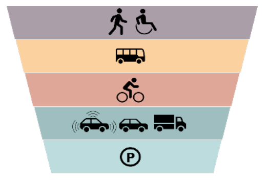


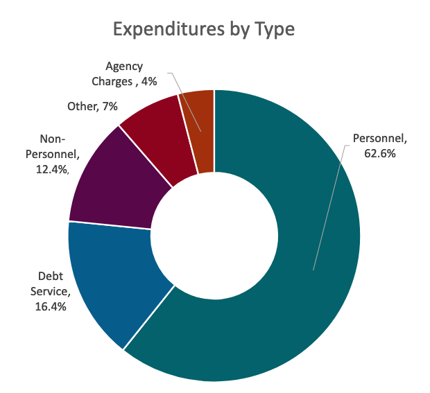 For example, the


